Oncala geodata
Oncala (Castille and León) is a seat of a third-order administrative division; located in Spain in Europe/Madrid (GMT+2) time zone. With population of 107 people, there are 5841 cities with bigger population in this country. Compared to other cities in Spain, 72.9% of cities are located further ↓South; 63.2% of cities are located further ←West and 98.6% of cities have lower elevation than Oncala. Note1


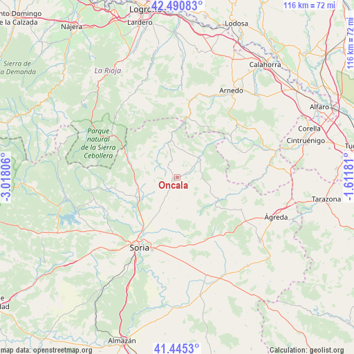
Oncala GPS coordinates[2]
41° 58' 12.756" North, 2° 18' 53.748" West
| Map corner | latitude | longitude |
|---|---|---|
| Upper-left | 42.49083°, | -3.01806° |
| Center: | 41.97021°, | -2.31493° |
| Lower-right: | 41.4453°, | -1.61181° |
| Map W x H: | 116.3×116.3 km | = 72.3×72.3mi |
| max Lat: | 43.74134° ⇑27.1% North |
| Oncala: | 41.97021° |
| min Lat: | ⇓72.9% South 27.64134° |
| min Long | Oncala | max Long |
| -18.00367° | -2.31493° | 4.2899° |
| W 63.2%⇐ | ⇒36.8% E |
Elevation
Elevation of Oncala is 1304 m = 4278 ft, and this is 706 m = 2316 ft above average elevation for this country.
| Max E: |
1682 m = 5518 ft | 1.4% |
| Oncala | 1304 m 4278 ft | |
| Avg. | 598 m = 1962 ft | |
Min E: |
0 m = 0 ft | 98.6% |
See also: Spain elevation on elevation.city.
Geographical zone
Oncala is located in North temperate zone (between Tropic of Cancer and the Arctic Circle). Distance of this Northern Tropic circle is 2060.7 km =1280.5 mi to South.| Distance of | km | miles | from Oncala |
|---|---|---|---|
| North Pole | 5340.4 | 3318.4 | to North |
| Arctic Circle | 2734.5 | 1699.1 | to North |
| Tropic Cancer | 2060.7 | 1280.5 | to South |
| Equator | 4666.6 | 2899.7 | to South |


Nearby cities:
15 places around Oncala: (largest is in red/bold)
• Aldealseñor
10.2 km =6.3 mi,  180°
180°
• Almajano
13.4 km =8.3 mi,  188°
188°
• Almarza
13 km =8.1 mi,  258°
258°
• Arévalo de la Sierra
7.5 km =4.7 mi,  250°
250°
• Ausejo de la Sierra
9.7 km =6 mi,  210°
210°
• Carrascosa de la Sierra
8.8 km =5.5 mi,  160°
160°
• Castilfrío de la Sierra
5.7 km =3.5 mi,  171°
171°
• Cerbón
12.9 km =8 mi,  110°
110°
• Cirujales del Río
11.5 km =7.1 mi, 184°
• Estepa de San Juan
5.1 km =3.2 mi,  197°
197°
• Fuentes de Magaña
11.9 km =7.4 mi, 109°
• San Pedro Manrique
9.5 km =5.9 mi,  46°
46°
• Valtajeros
8.4 km =5.2 mi,  115°
115°
• Villar del Río
12.1 km =7.5 mi,  345°
345°
• Vizmanos
9.7 km =6 mi,  307°
307°
Sources, notices
• [Note1] Compared only with cities in Spain existing in our database
• [Src1] Map data: © OpenStreetMap contributors (CC-BY-SA)
• [Src2] Other city data from geonames.org with taken over terms of usage.
• [Src3] Geographical zone / Annual Mean Temperature by Robert A. Rohde @ Wikipedia
