Almarza geodata
Almarza (Castille and León) is a seat of a third-order administrative division; located in Spain in Europe/Madrid (GMT+2) time zone. With population of 620 people, there are 3569 cities with bigger population in this country. Compared to other cities in Spain, 72.1% of cities are located further ↓South; 61.3% of cities are located further ←West and 95.6% of cities have lower elevation than Almarza. Note1


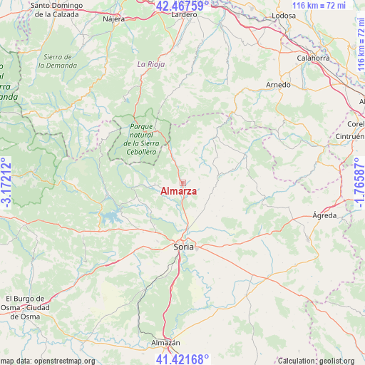
Almarza GPS coordinates[2]
41° 56' 48.408" North, 2° 28' 8.4" West
| Map corner | latitude | longitude |
|---|---|---|
| Upper-left | 42.46759°, | -3.17212° |
| Center: | 41.94678°, | -2.469° |
| Lower-right: | 41.42168°, | -1.76587° |
| Map W x H: | 116.3×116.3 km | = 72.3×72.3mi |
| max Lat: | 43.74134° ⇑27.9% North |
| Almarza: | 41.94678° |
| min Lat: | ⇓72.1% South 27.64134° |
| min Long | Almarza | max Long |
| -18.00367° | -2.469° | 4.2899° |
| W 61.3%⇐ | ⇒38.7% E |
Elevation
Elevation of Almarza is 1153 m = 3783 ft, and this is 555 m = 1821 ft above average elevation for this country.
| Max E: |
1682 m = 5518 ft | 4.4% |
| Almarza | 1153 m 3783 ft | |
| Avg. | 598 m = 1962 ft | |
Min E: |
0 m = 0 ft | 95.6% |
See also: Spain elevation on elevation.city.
Geographical zone
Almarza is located in North temperate zone (between Tropic of Cancer and the Arctic Circle). Distance of this Northern Tropic circle is 2058.1 km =1278.8 mi to South.| Distance of | km | miles | from Almarza |
|---|---|---|---|
| North Pole | 5343 | 3320 | to North |
| Arctic Circle | 2737.1 | 1700.8 | to North |
| Tropic Cancer | 2058.1 | 1278.8 | to South |
| Equator | 4664 | 2898.1 | to South |


Nearby cities:
15 places around Almarza: (largest is in red/bold)
• Arévalo de la Sierra
5.7 km =3.5 mi,  89°
89°
• Ausejo de la Sierra
9.8 km =6.1 mi,  126°
126°
• Buitrago
12.1 km =7.5 mi,  155°
155°
• Castilfrío de la Sierra
13.9 km =8.6 mi,  102°
102°
• Estepa de San Juan
11.5 km =7.1 mi, 101°
• Fuentecantos
11.3 km =7 mi, 162°
• Fuentelsaz de Soria
10 km =6.2 mi,  153°
153°
• Garray
14.6 km =9.1 mi,  172°
172°
• Oncala
13 km =8.1 mi,  78°
78°
• Rollamienta
5.6 km =3.5 mi,  245°
245°
• Santa Cruz de Yanguas
13 km =8.1 mi,  7°
7°
• Sotillo del Rincón
11.2 km =7 mi,  261°
261°
• Valdeavellano de Tera
8.9 km =5.5 mi,  266°
266°
• Villar del Ala
8.7 km =5.4 mi, 247°
• Vizmanos
9.9 km =6.2 mi,  30°
30°
Sources, notices
• [Note1] Compared only with cities in Spain existing in our database
• [Src1] Map data: © OpenStreetMap contributors (CC-BY-SA)
• [Src2] Other city data from geonames.org with taken over terms of usage.
• [Src3] Geographical zone / Annual Mean Temperature by Robert A. Rohde @ Wikipedia
