Navaleno geodata
Navaleno (Castille and León) is a seat of a third-order administrative division; located in Spain in Europe/Madrid (GMT+2) time zone. With population of 997 people, there are 2950 cities with bigger population in this country. Compared to other cities in Spain, 69.6% of cities are located further ↓South; 54.4% of cities are located further ←West and 94% of cities have lower elevation than Navaleno. Note1
Administrative division(s):
- Level 1: Castille and León
- Level 2: Provincia de Soria
- Level 3: Navaleno


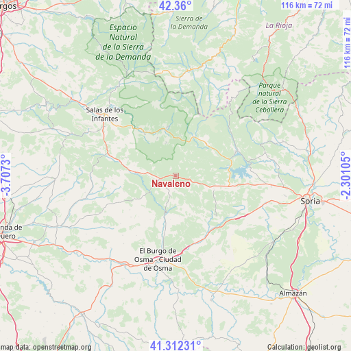
Navaleno GPS coordinates[2]
41° 50' 17.88" North, 3° 0' 15.048" West
| Map corner | latitude | longitude |
|---|---|---|
| Upper-left | 42.36°, | -3.7073° |
| Center: | 41.8383°, | -3.00418° |
| Lower-right: | 41.31231°, | -2.30105° |
| Map W x H: | 116.5×116.5 km | = 72.4×72.4mi |
| max Lat: | 43.74134° ⇑30.4% North |
| Navaleno: | 41.8383° |
| min Lat: | ⇓69.6% South 27.64134° |
| min Long | Navaleno | max Long |
| -18.00367° | -3.00418° | 4.2899° |
| W 54.4%⇐ | ⇒45.6% E |
Elevation
Elevation of Navaleno is 1116 m = 3661 ft, and this is 518 m = 1699 ft above average elevation for this country.
| Max E: |
1682 m = 5518 ft | 6% |
| Navaleno | 1116 m 3661 ft | |
| Avg. | 598 m = 1962 ft | |
Min E: |
0 m = 0 ft | 94% |
See also: Spain elevation on elevation.city.
Geographical zone
Navaleno is located in North temperate zone (between Tropic of Cancer and the Arctic Circle). Distance of this Northern Tropic circle is 2046.1 km =1271.4 mi to South.| Distance of | km | miles | from Navaleno |
|---|---|---|---|
| North Pole | 5355.1 | 3327.5 | to North |
| Arctic Circle | 2749.2 | 1708.3 | to North |
| Tropic Cancer | 2046.1 | 1271.4 | to South |
| Equator | 4652 | 2890.6 | to South |


Nearby cities:
15 places around Navaleno: (largest is in red/bold)
• Cabrejas del Pinar
13.7 km =8.5 mi,  110°
110°
• Canicosa de la Sierra
11.4 km =7.1 mi,  344°
344°
• Casarejos
5.2 km =3.2 mi,  206°
206°
• Covaleda
14.7 km =9.1 mi,  42°
42°
• Cubilla
11.4 km =7.1 mi,  150°
150°
• Duruelo de la Sierra
14.3 km =8.9 mi,  25°
25°
• Herrera de Soria
8.4 km =5.2 mi,  184°
184°
• Hontoria del Pinar
13.2 km =8.2 mi,  274°
274°
• Muriel Viejo
9.6 km =6 mi,  130°
130°
• Regumiel de la Sierra
13.2 km =8.2 mi,  5°
5°
• San Leonardo de Yagüe
5.4 km =3.4 mi,  260°
260°
• Santa María de las Hoyas
13.6 km =8.5 mi,  236°
236°
• Ucero
14.1 km =8.8 mi,  196°
196°
• Vadillo
5.3 km =3.3 mi, 183°
• Vilviestre del Pinar
13.9 km =8.6 mi,  333°
333°
Sources, notices
• [Note1] Compared only with cities in Spain existing in our database
• [Src1] Map data: © OpenStreetMap contributors (CC-BY-SA)
• [Src2] Other city data from geonames.org with taken over terms of usage.
• [Src3] Geographical zone / Annual Mean Temperature by Robert A. Rohde @ Wikipedia
