Monleón geodata
Monleón (Castille and León) is a seat of a third-order administrative division; located in Spain in Europe/Madrid (GMT+2) time zone. With population of 119 people, there are 5710 cities with bigger population in this country. Compared to other cities in Spain, 60.3% of cities are located further ↑North; 83.8% of cities are located further →East and 77.2% of cities have lower elevation than Monleón. Note1
Administrative division(s):
- Level 1: Castille and León
- Level 2: Provincia de Salamanca
- Level 3: Monleón


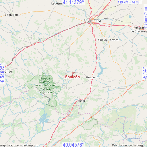
Monleón GPS coordinates[2]
40° 34' 54.912" North, 5° 50' 35.232" West
| Map corner | latitude | longitude |
|---|---|---|
| Upper-left | 41.11379°, | -6.54625° |
| Center: | 40.58192°, | -5.84312° |
| Lower-right: | 40.04578°, | -5.14° |
| Map W x H: | 118.8×118.8 km | = 73.8×73.8mi |
| max Lat: | 43.74134° ⇑60.3% North |
| Monleón: | 40.58192° |
| min Lat: | ⇓39.7% South 27.64134° |
| min Long | Monleón | max Long |
| -18.00367° | -5.84312° | 4.2899° |
| W 16.2%⇐ | ⇒83.8% E |
Elevation
Elevation of Monleón is 872 m = 2861 ft, and this is 274 m = 899 ft above average elevation for this country.
| Max E: |
1682 m = 5518 ft | 22.8% |
| Monleón | 872 m 2861 ft | |
| Avg. | 598 m = 1962 ft | |
Min E: |
0 m = 0 ft | 77.2% |
See also: Spain elevation on elevation.city.
Geographical zone
Monleón is located in North temperate zone (between Tropic of Cancer and the Arctic Circle). Distance of this Northern Tropic circle is 1906.4 km =1184.6 mi to South.| Distance of | km | miles | from Monleón |
|---|---|---|---|
| North Pole | 5494.8 | 3414.3 | to North |
| Arctic Circle | 2888.9 | 1795.1 | to North |
| Tropic Cancer | 1906.4 | 1184.6 | to South |
| Equator | 4512.3 | 2803.8 | to South |


Nearby cities:
15 places around Monleón: (largest is in red/bold)
• Casafranca
7.1 km =4.4 mi,  80°
80°
• Endrinal
3.4 km =2.1 mi,  72°
72°
• Escurial de la Sierra
10.2 km =6.3 mi,  292°
292°
• Frades de la Sierra
9.8 km =6.1 mi,  31°
31°
• Fuenterroble de Salvatierra
9.4 km =5.8 mi,  101°
101°
• Herguijuela del Campo
5.7 km =3.5 mi,  342°
342°
• Linares de Riofrío
6.6 km =4.1 mi,  271°
271°
• Los Santos
5.7 km =3.5 mi,  137°
137°
• Puebla de San Medel
12 km =7.5 mi,  131°
131°
• San Esteban de la Sierra
9.9 km =6.2 mi,  212°
212°
• San Miguel de Valero
8 km =5 mi,  237°
237°
• Santibáñez de la Sierra
11.5 km =7.1 mi, 212°
• Valdelacasa
10.8 km =6.7 mi, 141°
• Valero
9.9 km =6.2 mi, 238°
• Valverde de Valdelacasa
12.3 km =7.6 mi,  154°
154°
Sources, notices
• [Note1] Compared only with cities in Spain existing in our database
• [Src1] Map data: © OpenStreetMap contributors (CC-BY-SA)
• [Src2] Other city data from geonames.org with taken over terms of usage.
• [Src3] Geographical zone / Annual Mean Temperature by Robert A. Rohde @ Wikipedia
