Ledanca geodata
Ledanca (Castille-La Mancha) is a seat of a third-order administrative division; located in Spain in Europe/Madrid (GMT+2) time zone. With population of 124 people, there are 5647 cities with bigger population in this country. Compared to other cities in Spain, 54.6% of cities are located further ↑North; 56.9% of cities are located further ←West and 81.4% of cities have lower elevation than Ledanca. Note1
Administrative division(s):
- Level 1: Castille-La Mancha
- Level 2: Provincia de Guadalajara
- Level 3: Ledanca


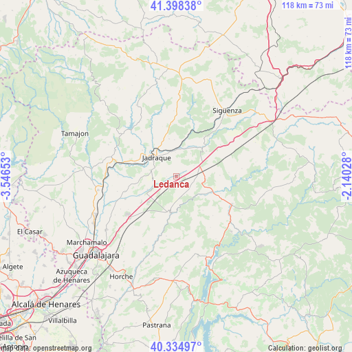
Ledanca GPS coordinates[2]
40° 52' 7.716" North, 2° 50' 36.24" West
| Map corner | latitude | longitude |
|---|---|---|
| Upper-left | 41.39838°, | -3.54653° |
| Center: | 40.86881°, | -2.8434° |
| Lower-right: | 40.33497°, | -2.14028° |
| Map W x H: | 118.2×118.2 km | = 73.4×73.4mi |
| max Lat: | 43.74134° ⇑54.6% North |
| Ledanca: | 40.86881° |
| min Lat: | ⇓45.4% South 27.64134° |
| min Long | Ledanca | max Long |
| -18.00367° | -2.8434° | 4.2899° |
| W 56.9%⇐ | ⇒43.1% E |
Elevation
Elevation of Ledanca is 911 m = 2989 ft, and this is 313 m = 1027 ft above average elevation for this country.
| Max E: |
1682 m = 5518 ft | 18.6% |
| Ledanca | 911 m 2989 ft | |
| Avg. | 598 m = 1962 ft | |
Min E: |
0 m = 0 ft | 81.4% |
See also: Spain elevation on elevation.city.
Geographical zone
Ledanca is located in North temperate zone (between Tropic of Cancer and the Arctic Circle). Distance of this Northern Tropic circle is 1938.3 km =1204.4 mi to South.| Distance of | km | miles | from Ledanca |
|---|---|---|---|
| North Pole | 5462.9 | 3394.5 | to North |
| Arctic Circle | 2857 | 1775.3 | to North |
| Tropic Cancer | 1938.3 | 1204.4 | to South |
| Equator | 4544.2 | 2823.6 | to South |


Nearby cities:
15 places around Ledanca: (largest is in red/bold)
• Alaminos
9.9 km =6.2 mi,  93°
93°
• Almadrones
6.8 km =4.2 mi,  58°
58°
• Argecilla
2.3 km =1.4 mi,  52°
52°
• Bujalaro
8.3 km =5.2 mi,  336°
336°
• Casas de San Galindo
9.6 km =6 mi,  272°
272°
• Castejón de Henares
9 km =5.6 mi,  31°
31°
• Cogollor
8.6 km =5.3 mi,  105°
105°
• Gajanejos
5.1 km =3.2 mi,  233°
233°
• Jadraque
9.2 km =5.7 mi,  312°
312°
• Matillas
8.4 km =5.2 mi,  4°
4°
• Miralrío
8.7 km =5.4 mi,  284°
284°
• Muduex
10.7 km =6.6 mi,  245°
245°
• Utande
7.4 km =4.6 mi, 252°
• Villanueva de Argecilla
7 km =4.3 mi,  302°
302°
• Villaseca de Henares
10.9 km =6.8 mi,  20°
20°
Sources, notices
• [Note1] Compared only with cities in Spain existing in our database
• [Src1] Map data: © OpenStreetMap contributors (CC-BY-SA)
• [Src2] Other city data from geonames.org with taken over terms of usage.
• [Src3] Geographical zone / Annual Mean Temperature by Robert A. Rohde @ Wikipedia
