Utande geodata
Utande (Castille-La Mancha) is a seat of a third-order administrative division; located in Spain in Europe/Madrid (GMT+2) time zone. With population of 52 people, there are 6440 cities with bigger population in this country. Compared to other cities in Spain, 55% of cities are located further ↑North; 55.6% of cities are located further ←West and 73.5% of cities have lower elevation than Utande. Note1
Administrative division(s):
- Level 1: Castille-La Mancha
- Level 2: Provincia de Guadalajara
- Level 3: Utande


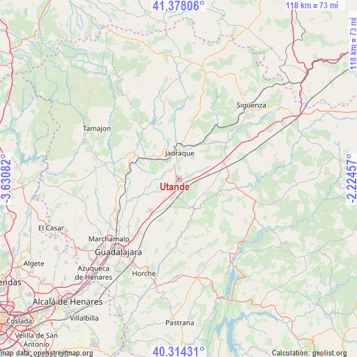
Utande GPS coordinates[2]
40° 50' 53.952" North, 2° 55' 39.72" West
| Map corner | latitude | longitude |
|---|---|---|
| Upper-left | 41.37806°, | -3.63082° |
| Center: | 40.84832°, | -2.9277° |
| Lower-right: | 40.31431°, | -2.22457° |
| Map W x H: | 118.3×118.3 km | = 73.5×73.5mi |
| max Lat: | 43.74134° ⇑55% North |
| Utande: | 40.84832° |
| min Lat: | ⇓45% South 27.64134° |
| min Long | Utande | max Long |
| -18.00367° | -2.9277° | 4.2899° |
| W 55.6%⇐ | ⇒44.4% E |
Elevation
Elevation of Utande is 839 m = 2753 ft, and this is 241 m = 791 ft above average elevation for this country.
| Max E: |
1682 m = 5518 ft | 26.5% |
| Utande | 839 m 2753 ft | |
| Avg. | 598 m = 1962 ft | |
Min E: |
0 m = 0 ft | 73.5% |
See also: Spain elevation on elevation.city.
Geographical zone
Utande is located in North temperate zone (between Tropic of Cancer and the Arctic Circle). Distance of this Northern Tropic circle is 1936 km =1203 mi to South.| Distance of | km | miles | from Utande |
|---|---|---|---|
| North Pole | 5465.2 | 3395.9 | to North |
| Arctic Circle | 2859.3 | 1776.7 | to North |
| Tropic Cancer | 1936 | 1203 | to South |
| Equator | 4541.9 | 2822.2 | to South |


Nearby cities:
15 places around Utande: (largest is in red/bold)
• Argecilla
9.6 km =6 mi,  67°
67°
• Brihuega
10.9 km =6.8 mi,  153°
153°
• Bujalaro
10.5 km =6.5 mi,  20°
20°
• Casas de San Galindo
3.7 km =2.3 mi,  316°
316°
• Copernal
10.8 km =6.7 mi,  279°
279°
• Gajanejos
3.1 km =1.9 mi,  104°
104°
• Hita
10.3 km =6.4 mi,  253°
253°
• Jadraque
8.5 km =5.3 mi,  1°
1°
• Ledanca
7.4 km =4.6 mi, 72°
• Membrillera
11.9 km =7.4 mi,  338°
338°
• Miralrío
4.7 km =2.9 mi, 343°
• Muduex
3.4 km =2.1 mi,  231°
231°
• Trijueque
9.9 km =6.2 mi,  213°
213°
• Valdearenas
6.9 km =4.3 mi, 231°
• Villanueva de Argecilla
6.1 km =3.8 mi,  10°
10°
Sources, notices
• [Note1] Compared only with cities in Spain existing in our database
• [Src1] Map data: © OpenStreetMap contributors (CC-BY-SA)
• [Src2] Other city data from geonames.org with taken over terms of usage.
• [Src3] Geographical zone / Annual Mean Temperature by Robert A. Rohde @ Wikipedia
