Lanestosa geodata
Lanestosa (Basque Country) is a seat of a third-order administrative division; located in Spain in Europe/Madrid (GMT+2) time zone. In our database, there are 6762 cities with bigger population. Compared to other cities in Spain, 96.6% of cities are located further ↓South; 51.3% of cities are located further →East and 76.2% of cities have higher elevation than Lanestosa. Note1


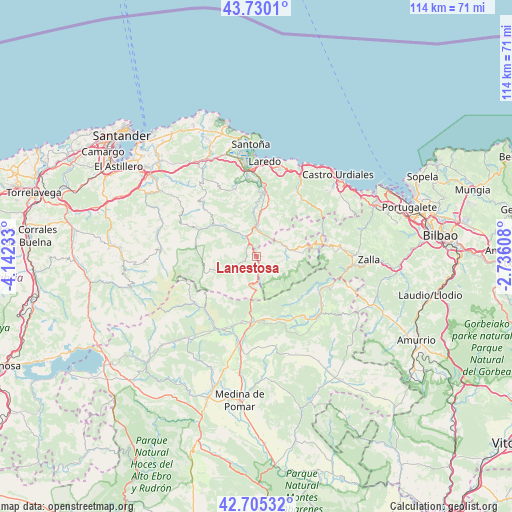
Lanestosa GPS coordinates[2]
43° 13' 11.496" North, 3° 26' 21.12" West
| Map corner | latitude | longitude |
|---|---|---|
| Upper-left | 43.7301°, | -4.14233° |
| Center: | 43.21986°, | -3.4392° |
| Lower-right: | 42.70532°, | -2.73608° |
| Map W x H: | 113.9×113.9 km | = 70.8×70.8mi |
| max Lat: | 43.74134° ⇑3.4% North |
| Lanestosa: | 43.21986° |
| min Lat: | ⇓96.6% South 27.64134° |
| min Long | Lanestosa | max Long |
| -18.00367° | -3.4392° | 4.2899° |
| W 48.7%⇐ | ⇒51.3% E |
Elevation
Elevation of Lanestosa is 283 m = 928 ft, and this is 315 m = 1033 ft below average elevation for this country.
| Max E: |
1682 m = 5518 ft | 76.2% |
| Avg. | 598 m = 1962 ft | |
| Lanestosa | 283 m = 928 ft | |
Min E: |
0 m = 0 ft | 23.8% |
See also: Spain elevation on elevation.city.
Geographical zone
Lanestosa is located in North temperate zone (between Tropic of Cancer and the Arctic Circle). Distance of this Northern Tropic circle is 2199.7 km =1366.8 mi to South.| Distance of | km | miles | from Lanestosa |
|---|---|---|---|
| North Pole | 5201.5 | 3232.1 | to North |
| Arctic Circle | 2595.6 | 1612.8 | to North |
| Tropic Cancer | 2199.7 | 1366.8 | to South |
| Equator | 4805.6 | 2986.1 | to South |


Nearby cities:
15 places around Lanestosa: (largest is in red/bold)
• Ampuero
13.8 km =8.6 mi,  7°
7°
• Arredondo
14.3 km =8.9 mi,  294°
294°
• Avellaneda
22.5 km =14 mi,  87°
87°
• Balmaseda
19.5 km =12.1 mi,  96°
96°
• Bárcena de Cicero
23.2 km =14.4 mi,  345°
345°
• Colindres
19.7 km =12.2 mi,  356°
356°
• Espinosa de los Monteros
18.3 km =11.4 mi,  210°
210°
• Hazas de Cesto
23.1 km =14.4 mi,  328°
328°
• Laredo
21.2 km =13.2 mi, 5°
• Liendo
20.9 km =13 mi,  15°
15°
• Limpias
16.1 km =10 mi, 6°
• Ramales de la Victoria
4.7 km =2.9 mi, 333°
• Rasines
9.5 km =5.9 mi,  4°
4°
• Solórzano
21.7 km =13.5 mi, 326°
• Villasana de Mena
18.4 km =11.4 mi,  136°
136°
Sources, notices
• [Note1] Compared only with cities in Spain existing in our database
• [Src1] Map data: © OpenStreetMap contributors (CC-BY-SA)
• [Src2] Other city data from geonames.org with taken over terms of usage.
• [Src3] Geographical zone / Annual Mean Temperature by Robert A. Rohde @ Wikipedia
