l'Escala geodata
l'Escala (Catalonia) is a populated place; located in Spain in Europe/Madrid (GMT+2) time zone. With population of 10,140 people, there are 852 cities with bigger population in this country. Compared to other cities in Spain, 77.2% of cities are located further ↓South; 99.5% of cities are located further ←West and 97% of cities have higher elevation than l'Escala. Note1


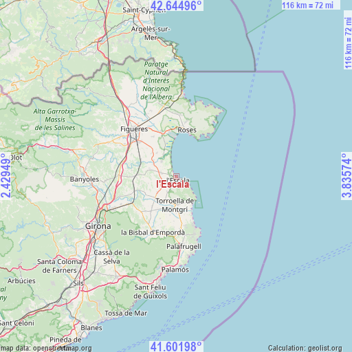
l'Escala GPS coordinates[2]
42° 7' 32.232" North, 3° 7' 57.396" East
| Map corner | latitude | longitude |
|---|---|---|
| Upper-left | 42.64496°, | 2.42949° |
| Center: | 42.12562°, | 3.13261° |
| Lower-right: | 41.60198°, | 3.83574° |
| Map W x H: | 116×116 km | = 72.1×72.1mi |
| max Lat: | 43.74134° ⇑22.8% North |
| l'Escala: | 42.12562° |
| min Lat: | ⇓77.2% South 27.64134° |
| min Long | l'Escala | max Long |
| -18.00367° | 3.13261° | 4.2899° |
| W 99.5%⇐ | ⇒0.5% E |
Elevation
Elevation of l'Escala is 15 m = 49 ft, and this is 583 m = 1913 ft below average elevation for this country.
| Max E: |
1682 m = 5518 ft | 97% |
| Avg. | 598 m = 1962 ft | |
| l'Escala | 15 m = 49 ft | |
Min E: |
0 m = 0 ft | 3% |
See also: Spain elevation on elevation.city.
Geographical zone
l'Escala is located in North temperate zone (between Tropic of Cancer and the Arctic Circle). Distance of this Northern Tropic circle is 2078 km =1291.2 mi to South.| Distance of | km | miles | from l'Escala |
|---|---|---|---|
| North Pole | 5323.1 | 3307.6 | to North |
| Arctic Circle | 2717.2 | 1688.4 | to North |
| Tropic Cancer | 2078 | 1291.2 | to South |
| Equator | 4683.9 | 2910.4 | to South |


Nearby cities:
15 places around l'Escala: (largest is in red/bold)
• Albons
4.7 km =2.9 mi,  238°
238°
• Garrigoles
8.7 km =5.4 mi,  250°
250°
• Gualta
11 km =6.8 mi,  192°
192°
• Jafre
11.7 km =7.3 mi, 239°
• Sant Pere Pescador
8.1 km =5 mi,  329°
329°
• Torroella de Fluvià
9.4 km =5.8 mi,  305°
305°
• Torroella de Montgrí
9.2 km =5.7 mi,  182°
182°
• Ullà
8.7 km =5.4 mi, 193°
• Ventalló
9.1 km =5.7 mi,  286°
286°
• Verges
10 km =6.2 mi,  225°
225°
• Vilamacolum
10 km =6.2 mi,  321°
321°
• Vilopriu
11.3 km =7 mi,  255°
255°
• l'Armentera
7 km =4.3 mi, 316°
• l'Estartit
9.7 km =6 mi,  146°
146°
• la Tallada d'Empordà
8.1 km =5 mi, 231°
Sources, notices
• [Note1] Compared only with cities in Spain existing in our database
• [Src1] Map data: © OpenStreetMap contributors (CC-BY-SA)
• [Src2] Other city data from geonames.org with taken over terms of usage.
• [Src3] Geographical zone / Annual Mean Temperature by Robert A. Rohde @ Wikipedia
