Garrigoles geodata
Garrigoles (Catalonia) is a seat of a third-order administrative division; located in Spain in Europe/Madrid (GMT+2) time zone. In our database, there are 6762 cities with bigger population. Compared to other cities in Spain, 76.5% of cities are located further ↓South; 98.9% of cities are located further ←West and 88.3% of cities have higher elevation than Garrigoles. Note1


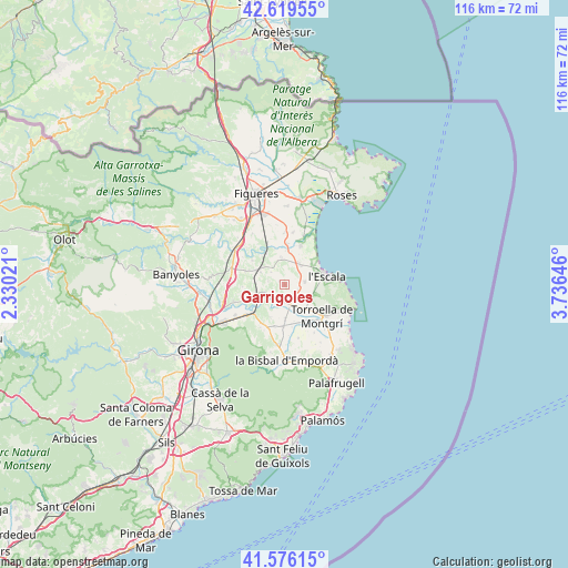
Garrigoles GPS coordinates[2]
42° 6' 0" North, 3° 1' 59.988" East
| Map corner | latitude | longitude |
|---|---|---|
| Upper-left | 42.61955°, | 2.33021° |
| Center: | 42.1°, | 3.03333° |
| Lower-right: | 41.57615°, | 3.73646° |
| Map W x H: | 116×116 km | = 72.1×72.1mi |
| max Lat: | 43.74134° ⇑23.5% North |
| Garrigoles: | 42.1° |
| min Lat: | ⇓76.5% South 27.64134° |
| min Long | Garrigoles | max Long |
| -18.00367° | 3.03333° | 4.2899° |
| W 98.9%⇐ | ⇒1.1% E |
Elevation
Elevation of Garrigoles is 91 m = 299 ft, and this is 507 m = 1663 ft below average elevation for this country.
| Max E: |
1682 m = 5518 ft | 88.3% |
| Avg. | 598 m = 1962 ft | |
| Garrigoles | 91 m = 299 ft | |
Min E: |
0 m = 0 ft | 11.7% |
See also: Spain elevation on elevation.city.
Geographical zone
Garrigoles is located in North temperate zone (between Tropic of Cancer and the Arctic Circle). Distance of this Northern Tropic circle is 2075.2 km =1289.5 mi to South.| Distance of | km | miles | from Garrigoles |
|---|---|---|---|
| North Pole | 5326 | 3309.4 | to North |
| Arctic Circle | 2720.1 | 1690.2 | to North |
| Tropic Cancer | 2075.2 | 1289.5 | to South |
| Equator | 4681.1 | 2908.7 | to South |


Nearby cities:
15 places around Garrigoles: (largest is in red/bold)
• Albons
4.2 km =2.6 mi,  84°
84°
• Colomers
4.5 km =2.8 mi,  245°
245°
• Flaçà
6.6 km =4.1 mi,  236°
236°
• Foixà
7.6 km =4.7 mi,  201°
201°
• Jafre
3.6 km =2.2 mi,  211°
211°
• Sant Jordi Desvalls
7.8 km =4.8 mi, 241°
• Sant Mori
7.2 km =4.5 mi,  329°
329°
• Saus
5.9 km =3.7 mi,  307°
307°
• Torroella de Fluvià
8.4 km =5.2 mi,  3°
3°
• Ullà
8.3 km =5.2 mi,  132°
132°
• Ultramort
7.1 km =4.4 mi,  179°
179°
• Ventalló
5.5 km =3.4 mi,  353°
353°
• Verges
4.3 km =2.7 mi,  166°
166°
• Vilopriu
2.7 km =1.7 mi,  270°
270°
• la Tallada d'Empordà
2.9 km =1.8 mi,  139°
139°
Sources, notices
• [Note1] Compared only with cities in Spain existing in our database
• [Src1] Map data: © OpenStreetMap contributors (CC-BY-SA)
• [Src2] Other city data from geonames.org with taken over terms of usage.
• [Src3] Geographical zone / Annual Mean Temperature by Robert A. Rohde @ Wikipedia
