La Bañeza geodata
La Bañeza (Castille and León) is a populated place; located in Spain in Europe/Madrid (GMT+2) time zone. With population of 11,057 people, there are 797 cities with bigger population in this country. Compared to other cities in Spain, 81.8% of cities are located further ↓South; 84.7% of cities are located further →East and 64.8% of cities have lower elevation than La Bañeza. Note1
Administrative division(s):
- Level 1: Castille and León
- Level 2: Provincia de León
- Level 3: Bañeza, La


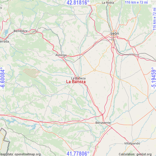
La Bañeza GPS coordinates[2]
42° 18' 0.936" North, 5° 53' 51.792" West
| Map corner | latitude | longitude |
|---|---|---|
| Upper-left | 42.81816°, | -6.60084° |
| Center: | 42.30026°, | -5.89772° |
| Lower-right: | 41.77806°, | -5.19459° |
| Map W x H: | 115.6×115.6 km | = 71.8×71.8mi |
| max Lat: | 43.74134° ⇑18.2% North |
| La Bañeza: | 42.30026° |
| min Lat: | ⇓81.8% South 27.64134° |
| min Long | La Bañeza | max Long |
| -18.00367° | -5.89772° | 4.2899° |
| W 15.3%⇐ | ⇒84.7% E |
Elevation
Elevation of La Bañeza is 776 m = 2546 ft, and this is 178 m = 584 ft above average elevation for this country.
| Max E: |
1682 m = 5518 ft | 35.2% |
| La Bañeza | 776 m 2546 ft | |
| Avg. | 598 m = 1962 ft | |
Min E: |
0 m = 0 ft | 64.8% |
See also: Spain elevation on elevation.city.
Geographical zone
La Bañeza is located in North temperate zone (between Tropic of Cancer and the Arctic Circle). Distance of this Northern Tropic circle is 2097.4 km =1303.3 mi to South.| Distance of | km | miles | from La Bañeza |
|---|---|---|---|
| North Pole | 5303.7 | 3295.6 | to North |
| Arctic Circle | 2697.8 | 1676.3 | to North |
| Tropic Cancer | 2097.4 | 1303.3 | to South |
| Equator | 4703.3 | 2922.5 | to South |


Nearby cities:
15 places around La Bañeza: (largest is in red/bold)
• Cebrones del Río
7.6 km =4.7 mi,  129°
129°
• Laguna Dalga
12.5 km =7.8 mi,  73°
73°
• Palacios de la Valduerna
4.5 km =2.8 mi,  312°
312°
• Quintana del Marco
11.1 km =6.9 mi,  159°
159°
• Quintana y Congosto
12.4 km =7.7 mi,  246°
246°
• Regueras de Arriba
3.2 km =2 mi,  102°
102°
• Riego de la Vega
12.2 km =7.6 mi,  325°
325°
• Roperuelos del Páramo
11.8 km =7.3 mi, 126°
• San Cristóbal de la Polantera
10.1 km =6.3 mi,  355°
355°
• Santa Elena de Jamuz
4.5 km =2.8 mi,  169°
169°
• Santa María de la Isla
6.6 km =4.1 mi,  337°
337°
• Soto de la Vega
3.8 km =2.4 mi,  19°
19°
• Valdefuentes del Páramo
6.1 km =3.8 mi,  64°
64°
• Villamontán de la Valduerna
8.2 km =5.1 mi,  277°
277°
• Villazala
7.6 km =4.7 mi,  26°
26°
Sources, notices
• [Note1] Compared only with cities in Spain existing in our database
• [Src1] Map data: © OpenStreetMap contributors (CC-BY-SA)
• [Src2] Other city data from geonames.org with taken over terms of usage.
• [Src3] Geographical zone / Annual Mean Temperature by Robert A. Rohde @ Wikipedia
