Juneda geodata
Juneda (Catalonia) is a seat of a third-order administrative division; located in Spain in Europe/Madrid (GMT+2) time zone. With population of 3,048 people, there are 1708 cities with bigger population in this country. Compared to other cities in Spain, 62% of cities are located further ↓South; 90% of cities are located further ←West and 77.2% of cities have higher elevation than Juneda. Note1


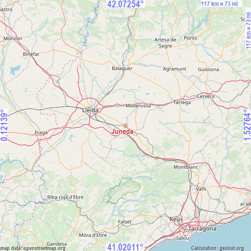
Juneda GPS coordinates[2]
41° 32' 54.492" North, 0° 49' 28.236" East
| Map corner | latitude | longitude |
|---|---|---|
| Upper-left | 42.07254°, | 0.12139° |
| Center: | 41.54847°, | 0.82451° |
| Lower-right: | 41.02011°, | 1.52764° |
| Map W x H: | 117×117 km | = 72.7×72.7mi |
| max Lat: | 43.74134° ⇑38% North |
| Juneda: | 41.54847° |
| min Lat: | ⇓62% South 27.64134° |
| min Long | Juneda | max Long |
| -18.00367° | 0.82451° | 4.2899° |
| W 90%⇐ | ⇒10% E |
Elevation
Elevation of Juneda is 267 m = 876 ft, and this is 331 m = 1086 ft below average elevation for this country.
| Max E: |
1682 m = 5518 ft | 77.2% |
| Avg. | 598 m = 1962 ft | |
| Juneda | 267 m = 876 ft | |
Min E: |
0 m = 0 ft | 22.8% |
See also: Spain elevation on elevation.city.
Geographical zone
Juneda is located in North temperate zone (between Tropic of Cancer and the Arctic Circle). Distance of this Northern Tropic circle is 2013.8 km =1251.3 mi to South.| Distance of | km | miles | from Juneda |
|---|---|---|---|
| North Pole | 5387.3 | 3347.5 | to North |
| Arctic Circle | 2781.4 | 1728.3 | to North |
| Tropic Cancer | 2013.8 | 1251.3 | to South |
| Equator | 4619.8 | 2870.6 | to South |


Nearby cities:
15 places around Juneda: (largest is in red/bold)
• Alcoletge
15.5 km =9.6 mi,  315°
315°
• Arbeca
8.4 km =5.2 mi,  95°
95°
• Aspa
14 km =8.7 mi,  244°
244°
• Belianes
16 km =9.9 mi,  85°
85°
• Bellvís
13.8 km =8.6 mi,  357°
357°
• Castelldans
7.2 km =4.5 mi,  221°
221°
• Castellnou de Seana
16.5 km =10.3 mi,  47°
47°
• Fondarella
10.4 km =6.5 mi,  22°
22°
• Golmés
13 km =8.1 mi,  43°
43°
• Miralcamp
7.8 km =4.8 mi, 36°
• Mollerussa
11.3 km =7 mi,  33°
33°
• Sidamon
9.5 km =5.9 mi,  4°
4°
• Vilanova de Bellpuig
13.7 km =8.5 mi,  58°
58°
• el Cogul
14.9 km =9.3 mi,  232°
232°
• el Poal
15.4 km =9.6 mi,  13°
13°
Sources, notices
• [Note1] Compared only with cities in Spain existing in our database
• [Src1] Map data: © OpenStreetMap contributors (CC-BY-SA)
• [Src2] Other city data from geonames.org with taken over terms of usage.
• [Src3] Geographical zone / Annual Mean Temperature by Robert A. Rohde @ Wikipedia
