Fondarella geodata
Fondarella (Catalonia) is a populated place; located in Spain in Europe/Madrid (GMT+2) time zone. With population of 761 people, there are 3289 cities with bigger population in this country. Compared to other cities in Spain, 64.4% of cities are located further ↓South; 90.1% of cities are located further ←West and 78.6% of cities have higher elevation than Fondarella. Note1


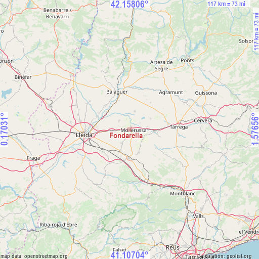
Fondarella GPS coordinates[2]
41° 38' 4.884" North, 0° 52' 24.348" East
| Map corner | latitude | longitude |
|---|---|---|
| Upper-left | 42.15806°, | 0.17031° |
| Center: | 41.63469°, | 0.87343° |
| Lower-right: | 41.10704°, | 1.57656° |
| Map W x H: | 116.9×116.9 km | = 72.6×72.6mi |
| max Lat: | 43.74134° ⇑35.6% North |
| Fondarella: | 41.63469° |
| min Lat: | ⇓64.4% South 27.64134° |
| min Long | Fondarella | max Long |
| -18.00367° | 0.87343° | 4.2899° |
| W 90.1%⇐ | ⇒9.9% E |
Elevation
Elevation of Fondarella is 246 m = 807 ft, and this is 352 m = 1155 ft below average elevation for this country.
| Max E: |
1682 m = 5518 ft | 78.6% |
| Avg. | 598 m = 1962 ft | |
| Fondarella | 246 m = 807 ft | |
Min E: |
0 m = 0 ft | 21.4% |
See also: Spain elevation on elevation.city.
Geographical zone
Fondarella is located in North temperate zone (between Tropic of Cancer and the Arctic Circle). Distance of this Northern Tropic circle is 2023.4 km =1257.3 mi to South.| Distance of | km | miles | from Fondarella |
|---|---|---|---|
| North Pole | 5377.7 | 3341.5 | to North |
| Arctic Circle | 2771.8 | 1722.3 | to North |
| Tropic Cancer | 2023.4 | 1257.3 | to South |
| Equator | 4629.3 | 2876.5 | to South |


Nearby cities:
15 places around Fondarella: (largest is in red/bold)
• Arbeca
11.2 km =7 mi,  157°
157°
• Barbens
12.9 km =8 mi,  67°
67°
• Bellpuig
11.5 km =7.1 mi,  94°
94°
• Bellvís
6.3 km =3.9 mi,  312°
312°
• Castellnou de Seana
8.2 km =5.1 mi,  79°
79°
• Golmés
4.8 km =3 mi, 91°
• Ivars d'Urgell
10.7 km =6.6 mi,  61°
61°
• Juneda
10.4 km =6.5 mi,  202°
202°
• Linyola
8.1 km =5 mi,  26°
26°
• Miralcamp
3.3 km =2.1 mi,  170°
170°
• Mollerussa
2.2 km =1.4 mi, 93°
• Sidamon
3.3 km =2.1 mi,  267°
267°
• Térmens
12.7 km =7.9 mi,  315°
315°
• Vilanova de Bellpuig
7.9 km =4.9 mi,  107°
107°
• el Poal
5.4 km =3.4 mi,  354°
354°
Sources, notices
• [Note1] Compared only with cities in Spain existing in our database
• [Src1] Map data: © OpenStreetMap contributors (CC-BY-SA)
• [Src2] Other city data from geonames.org with taken over terms of usage.
• [Src3] Geographical zone / Annual Mean Temperature by Robert A. Rohde @ Wikipedia
