Izagre geodata
Izagre (Castille and León) is a seat of a third-order administrative division; located in Spain in Europe/Madrid (GMT+2) time zone. With population of 207 people, there are 4996 cities with bigger population in this country. Compared to other cities in Spain, 79.9% of cities are located further ↓South; 75.8% of cities are located further →East and 66.1% of cities have lower elevation than Izagre. Note1


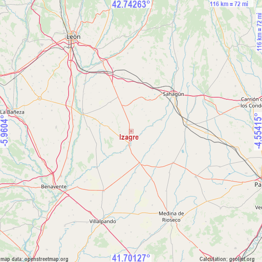
Izagre GPS coordinates[2]
42° 13' 26.76" North, 5° 15' 26.172" West
| Map corner | latitude | longitude |
|---|---|---|
| Upper-left | 42.74263°, | -5.9604° |
| Center: | 42.2241°, | -5.25727° |
| Lower-right: | 41.70127°, | -4.55415° |
| Map W x H: | 115.8×115.8 km | = 72×72mi |
| max Lat: | 43.74134° ⇑20.1% North |
| Izagre: | 42.2241° |
| min Lat: | ⇓79.9% South 27.64134° |
| min Long | Izagre | max Long |
| -18.00367° | -5.25727° | 4.2899° |
| W 24.2%⇐ | ⇒75.8% E |
Elevation
Elevation of Izagre is 785 m = 2575 ft, and this is 187 m = 614 ft above average elevation for this country.
| Max E: |
1682 m = 5518 ft | 33.9% |
| Izagre | 785 m 2575 ft | |
| Avg. | 598 m = 1962 ft | |
Min E: |
0 m = 0 ft | 66.1% |
See also: Spain elevation on elevation.city.
Geographical zone
Izagre is located in North temperate zone (between Tropic of Cancer and the Arctic Circle). Distance of this Northern Tropic circle is 2089 km =1298 mi to South.| Distance of | km | miles | from Izagre |
|---|---|---|---|
| North Pole | 5312.2 | 3300.8 | to North |
| Arctic Circle | 2706.3 | 1681.6 | to North |
| Tropic Cancer | 2089 | 1298 | to South |
| Equator | 4694.9 | 2917.3 | to South |


Nearby cities:
15 places around Izagre: (largest is in red/bold)
• Cabezón de Valderaduey
10.2 km =6.3 mi,  127°
127°
• Castilfalé
13.5 km =8.4 mi,  268°
268°
• Castrobol
10.7 km =6.6 mi,  205°
205°
• Castroponce
12.5 km =7.8 mi,  150°
150°
• Joarilla de las Matas
9.6 km =6 mi,  42°
42°
• Mayorga
6.4 km =4 mi,  184°
184°
• Melgar de Abajo
9.7 km =6 mi,  77°
77°
• Monasterio de Vega
6.3 km =3.9 mi, 83°
• Saelices de Mayorga
4.5 km =2.8 mi,  107°
107°
• Santervás de Campos
12.9 km =8 mi,  92°
92°
• Urones de Castroponce
14 km =8.7 mi,  188°
188°
• Valverde-Enrique
9.6 km =6 mi,  338°
338°
• Vega de Ruiponce
12.4 km =7.7 mi, 108°
• Villagómez la Nueva
12.1 km =7.5 mi, 128°
• Villalba de la Loma
7.8 km =4.8 mi, 134°
Sources, notices
• [Note1] Compared only with cities in Spain existing in our database
• [Src1] Map data: © OpenStreetMap contributors (CC-BY-SA)
• [Src2] Other city data from geonames.org with taken over terms of usage.
• [Src3] Geographical zone / Annual Mean Temperature by Robert A. Rohde @ Wikipedia
