Valverde-Enrique geodata
Valverde-Enrique (Castille and León) is a seat of a third-order administrative division; located in Spain in Europe/Madrid (GMT+2) time zone. With population of 208 people, there are 4993 cities with bigger population in this country. Compared to other cities in Spain, 81.9% of cities are located further ↓South; 76.4% of cities are located further →East and 73% of cities have lower elevation than Valverde-Enrique. Note1
Administrative division(s):
- Level 1: Castille and León
- Level 2: Provincia de León
- Level 3: Valverde-Enrique


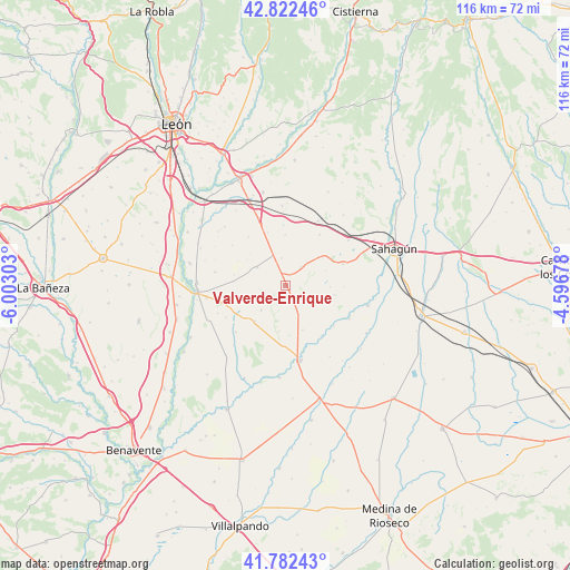
Valverde-Enrique GPS coordinates[2]
42° 18' 16.524" North, 5° 17' 59.64" West
| Map corner | latitude | longitude |
|---|---|---|
| Upper-left | 42.82246°, | -6.00303° |
| Center: | 42.30459°, | -5.2999° |
| Lower-right: | 41.78243°, | -4.59678° |
| Map W x H: | 115.6×115.6 km | = 71.8×71.8mi |
| max Lat: | 43.74134° ⇑18.1% North |
| Valverde-Enrique: | 42.30459° |
| min Lat: | ⇓81.9% South 27.64134° |
| min Long | Valverde-Enriqu | max Long |
| -18.00367° | -5.2999° | 4.2899° |
| W 23.6%⇐ | ⇒76.4% E |
Elevation
Elevation of Valverde-Enrique is 835 m = 2740 ft, and this is 237 m = 778 ft above average elevation for this country.
| Max E: |
1682 m = 5518 ft | 27% |
| Valverde-Enrique | 835 m 2740 ft | |
| Avg. | 598 m = 1962 ft | |
Min E: |
0 m = 0 ft | 73% |
See also: Spain elevation on elevation.city.
Geographical zone
Valverde-Enrique is located in North temperate zone (between Tropic of Cancer and the Arctic Circle). Distance of this Northern Tropic circle is 2097.9 km =1303.6 mi to South.| Distance of | km | miles | from Valverde-Enrique |
|---|---|---|---|
| North Pole | 5303.2 | 3295.3 | to North |
| Arctic Circle | 2697.3 | 1676 | to North |
| Tropic Cancer | 2097.9 | 1303.6 | to South |
| Equator | 4703.8 | 2922.8 | to South |


Nearby cities:
15 places around Valverde-Enrique: (largest is in red/bold)
• Castilfalé
13.7 km =8.5 mi,  226°
226°
• El Burgo Ranero
14.7 km =9.1 mi,  26°
26°
• Gordaliza del Pino
12.5 km =7.8 mi,  69°
69°
• Gusendos de los Oteros
13.5 km =8.4 mi,  307°
307°
• Izagre
9.6 km =6 mi,  158°
158°
• Joarilla de las Matas
10.2 km =6.3 mi,  100°
100°
• Matadeón de los Oteros
6.8 km =4.2 mi,  303°
303°
• Melgar de Abajo
14.7 km =9.1 mi,  117°
117°
• Monasterio de Vega
12.8 km =8 mi,  130°
130°
• Pajares de los Oteros
14.5 km =9 mi,  281°
281°
• Saelices de Mayorga
12.9 km =8 mi,  142°
142°
• Santa Cristina de Valmadrigal
5.6 km =3.5 mi,  352°
352°
• Vallecillo
9.3 km =5.8 mi,  51°
51°
• Villabraz
13.6 km =8.5 mi,  241°
241°
• Villamoratiel de las Matas
10.3 km =6.4 mi,  359°
359°
Sources, notices
• [Note1] Compared only with cities in Spain existing in our database
• [Src1] Map data: © OpenStreetMap contributors (CC-BY-SA)
• [Src2] Other city data from geonames.org with taken over terms of usage.
• [Src3] Geographical zone / Annual Mean Temperature by Robert A. Rohde @ Wikipedia
