Saus geodata
Saus (Catalonia) is a populated place; located in Spain in Europe/Madrid (GMT+2) time zone. With population of 719 people, there are 3371 cities with bigger population in this country. Compared to other cities in Spain, 77.4% of cities are located further ↓South; 98.5% of cities are located further ←West and 89.5% of cities have higher elevation than Saus. Note1
Administrative division(s):
- Level 1: Catalonia
- Level 2: Província de Girona
- Level 3: Saus, Camallera i Llampaies


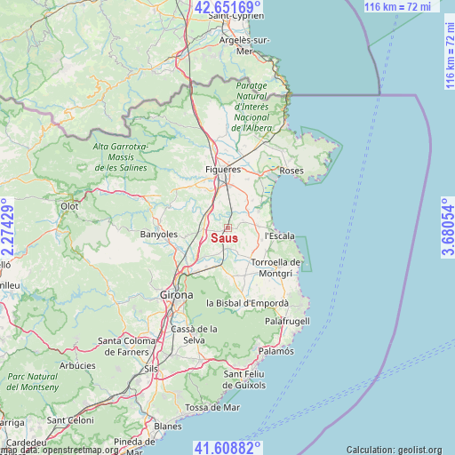
Saus GPS coordinates[2]
42° 7' 56.64" North, 2° 58' 38.712" East
| Map corner | latitude | longitude |
|---|---|---|
| Upper-left | 42.65169°, | 2.27429° |
| Center: | 42.1324°, | 2.97742° |
| Lower-right: | 41.60882°, | 3.68054° |
| Map W x H: | 116×116 km | = 72.1×72.1mi |
| max Lat: | 43.74134° ⇑22.6% North |
| Saus: | 42.1324° |
| min Lat: | ⇓77.4% South 27.64134° |
| min Long | Saus | max Long |
| -18.00367° | 2.97742° | 4.2899° |
| W 98.5%⇐ | ⇒1.5% E |
Elevation
Elevation of Saus is 75 m = 246 ft, and this is 523 m = 1716 ft below average elevation for this country.
| Max E: |
1682 m = 5518 ft | 89.5% |
| Avg. | 598 m = 1962 ft | |
| Saus | 75 m = 246 ft | |
Min E: |
0 m = 0 ft | 10.5% |
See also: Spain elevation on elevation.city.
Geographical zone
Saus is located in North temperate zone (between Tropic of Cancer and the Arctic Circle). Distance of this Northern Tropic circle is 2078.8 km =1291.7 mi to South.| Distance of | km | miles | from Saus |
|---|---|---|---|
| North Pole | 5322.4 | 3307.2 | to North |
| Arctic Circle | 2716.5 | 1688 | to North |
| Tropic Cancer | 2078.8 | 1291.7 | to South |
| Equator | 4684.7 | 2910.9 | to South |


Nearby cities:
15 places around Saus: (largest is in red/bold)
• Bàscara
6.3 km =3.9 mi,  298°
298°
• Colomers
5.5 km =3.4 mi,  174°
174°
• Flaçà
7.4 km =4.6 mi,  186°
186°
• Garrigoles
5.9 km =3.7 mi,  127°
127°
• Garrigàs
7 km =4.3 mi,  344°
344°
• Jafre
7.2 km =4.5 mi,  157°
157°
• Pontós
7.8 km =4.8 mi,  320°
320°
• Sant Jordi Desvalls
7.7 km =4.8 mi,  197°
197°
• Sant Miquel de Fluvià
4.6 km =2.9 mi,  15°
15°
• Sant Mori
2.8 km =1.7 mi, 20°
• Torroella de Fluvià
7 km =4.3 mi,  47°
47°
• Ventalló
4.4 km =2.7 mi,  65°
65°
• Viladasens
6.6 km =4.1 mi,  213°
213°
• Vilademuls
7.4 km =4.6 mi,  275°
275°
• Vilopriu
4.1 km =2.5 mi,  152°
152°
Sources, notices
• [Note1] Compared only with cities in Spain existing in our database
• [Src1] Map data: © OpenStreetMap contributors (CC-BY-SA)
• [Src2] Other city data from geonames.org with taken over terms of usage.
• [Src3] Geographical zone / Annual Mean Temperature by Robert A. Rohde @ Wikipedia
