Fuentestrún geodata
Fuentestrún (Castille and León) is a seat of a third-order administrative division; located in Spain in Europe/Madrid (GMT+2) time zone. With population of 87 people, there are 6070 cities with bigger population in this country. Compared to other cities in Spain, 70.4% of cities are located further ↓South; 66.4% of cities are located further ←West and 88.9% of cities have lower elevation than Fuentestrún. Note1
Administrative division(s):
- Level 1: Castille and León
- Level 2: Provincia de Soria
- Level 3: Fuentestrún


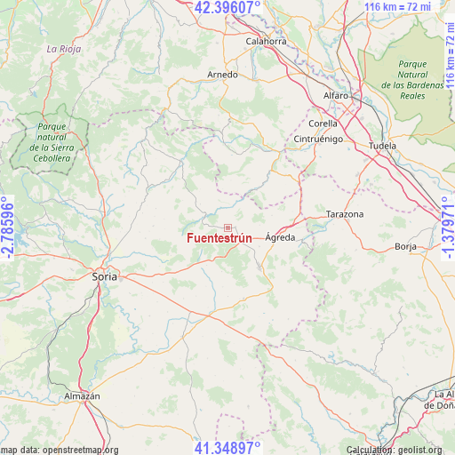
Fuentestrún GPS coordinates[2]
41° 52' 28.776" North, 2° 4' 58.188" West
| Map corner | latitude | longitude |
|---|---|---|
| Upper-left | 42.39607°, | -2.78596° |
| Center: | 41.87466°, | -2.08283° |
| Lower-right: | 41.34897°, | -1.37971° |
| Map W x H: | 116.4×116.4 km | = 72.3×72.3mi |
| max Lat: | 43.74134° ⇑29.6% North |
| Fuentestrún: | 41.87466° |
| min Lat: | ⇓70.4% South 27.64134° |
| min Long | Fuentestrún | max Long |
| -18.00367° | -2.08283° | 4.2899° |
| W 66.4%⇐ | ⇒33.6% E |
Elevation
Elevation of Fuentestrún is 1012 m = 3320 ft, and this is 414 m = 1358 ft above average elevation for this country.
| Max E: |
1682 m = 5518 ft | 11.1% |
| Fuentestrún | 1012 m 3320 ft | |
| Avg. | 598 m = 1962 ft | |
Min E: |
0 m = 0 ft | 88.9% |
See also: Spain elevation on elevation.city.
Geographical zone
Fuentestrún is located in North temperate zone (between Tropic of Cancer and the Arctic Circle). Distance of this Northern Tropic circle is 2050.1 km =1273.9 mi to South.| Distance of | km | miles | from Fuentestrún |
|---|---|---|---|
| North Pole | 5351 | 3325 | to North |
| Arctic Circle | 2745.1 | 1705.7 | to North |
| Tropic Cancer | 2050.1 | 1273.9 | to South |
| Equator | 4656 | 2893.1 | to South |


Nearby cities:
15 places around Fuentestrún: (largest is in red/bold)
• Aguilar del Río Alhama
12.2 km =7.6 mi,  37°
37°
• Castilruiz
2 km =1.2 mi,  83°
83°
• Cerbón
9.4 km =5.8 mi,  310°
310°
• Cigudosa
7.1 km =4.4 mi,  22°
22°
• Fuentes de Magaña
10.5 km =6.5 mi, 310°
• Magaña
7.2 km =4.5 mi,  293°
293°
• Matalebreras
4.8 km =3 mi,  141°
141°
• Navajún
10.3 km =6.4 mi,  352°
352°
• Pozalmuro
11.3 km =7 mi,  188°
188°
• San Felices
8.4 km =5.2 mi,  33°
33°
• Suellacabras
11.9 km =7.4 mi,  258°
258°
• Valdelagua del Cerro
3.1 km =1.9 mi,  299°
299°
• Valdemadera
12.2 km =7.6 mi,  3°
3°
• Valdeprado
7.3 km =4.5 mi,  342°
342°
• Villar del Campo
11 km =6.8 mi,  210°
210°
Sources, notices
• [Note1] Compared only with cities in Spain existing in our database
• [Src1] Map data: © OpenStreetMap contributors (CC-BY-SA)
• [Src2] Other city data from geonames.org with taken over terms of usage.
• [Src3] Geographical zone / Annual Mean Temperature by Robert A. Rohde @ Wikipedia
