Fuentespreadas geodata
Fuentespreadas (Castille and León) is a seat of a third-order administrative division; located in Spain in Europe/Madrid (GMT+2) time zone. With population of 369 people, there are 4239 cities with bigger population in this country. Compared to other cities in Spain, 55.8% of cities are located further ↓South; 80.5% of cities are located further →East and 63.1% of cities have lower elevation than Fuentespreadas. Note1
Administrative division(s):
- Level 1: Castille and León
- Level 2: Provincia de Zamora
- Level 3: Fuentespreadas


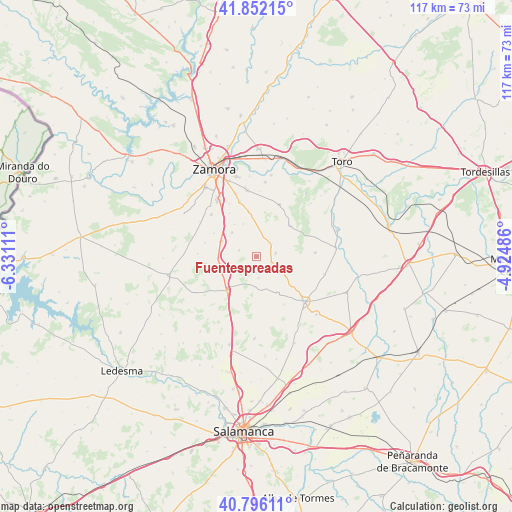
Fuentespreadas GPS coordinates[2]
41° 19' 34.572" North, 5° 37' 40.728" West
| Map corner | latitude | longitude |
|---|---|---|
| Upper-left | 41.85215°, | -6.33111° |
| Center: | 41.32627°, | -5.62798° |
| Lower-right: | 40.79611°, | -4.92486° |
| Map W x H: | 117.4×117.4 km | = 72.9×72.9mi |
| max Lat: | 43.74134° ⇑44.2% North |
| Fuentespreadas: | 41.32627° |
| min Lat: | ⇓55.8% South 27.64134° |
| min Long | Fuentespreadas | max Long |
| -18.00367° | -5.62798° | 4.2899° |
| W 19.5%⇐ | ⇒80.5% E |
Elevation
Elevation of Fuentespreadas is 765 m = 2510 ft, and this is 167 m = 548 ft above average elevation for this country.
| Max E: |
1682 m = 5518 ft | 36.9% |
| Fuentespreadas | 765 m 2510 ft | |
| Avg. | 598 m = 1962 ft | |
Min E: |
0 m = 0 ft | 63.1% |
See also: Spain elevation on elevation.city.
Geographical zone
Fuentespreadas is located in North temperate zone (between Tropic of Cancer and the Arctic Circle). Distance of this Northern Tropic circle is 1989.1 km =1236 mi to South.| Distance of | km | miles | from Fuentespreadas |
|---|---|---|---|
| North Pole | 5412 | 3362.9 | to North |
| Arctic Circle | 2806.1 | 1743.6 | to North |
| Tropic Cancer | 1989.1 | 1236 | to South |
| Equator | 4595.1 | 2855.3 | to South |


Nearby cities:
15 places around Fuentespreadas: (largest is in red/bold)
• Argujillo
3.7 km =2.3 mi,  115°
115°
• Cabañas de Sayago
13 km =8.1 mi,  273°
273°
• Casaseca de Campeán
11.2 km =7 mi,  298°
298°
• Cazurra
11.8 km =7.3 mi,  327°
327°
• Corrales
8.8 km =5.5 mi,  293°
293°
• Cuelgamures
3.3 km =2.1 mi,  229°
229°
• Gema
10.4 km =6.5 mi,  350°
350°
• Jambrina
7.9 km =4.9 mi,  337°
337°
• Peleas de Abajo
9 km =5.6 mi, 325°
• San Miguel de la Ribera
4.3 km =2.7 mi,  80°
80°
• Santa Clara de Avedillo
4.3 km =2.7 mi, 288°
• Sanzoles
12.8 km =8 mi,  23°
23°
• Venialbo
10.4 km =6.5 mi,  47°
47°
• Villamor de los Escuderos
9.3 km =5.8 mi,  151°
151°
• Villanueva de Campeán
12.3 km =7.6 mi,  284°
284°
Sources, notices
• [Note1] Compared only with cities in Spain existing in our database
• [Src1] Map data: © OpenStreetMap contributors (CC-BY-SA)
• [Src2] Other city data from geonames.org with taken over terms of usage.
• [Src3] Geographical zone / Annual Mean Temperature by Robert A. Rohde @ Wikipedia
