Villanueva de Campeán geodata
Villanueva de Campeán (Castille and León) is a seat of a third-order administrative division; located in Spain in Europe/Madrid (GMT+2) time zone. With population of 167 people, there are 5288 cities with bigger population in this country. Compared to other cities in Spain, 56.4% of cities are located further ↓South; 82.9% of cities are located further →East and 62.4% of cities have lower elevation than Villanueva de Campeán. Note1
Administrative division(s):
- Level 1: Castille and León
- Level 2: Provincia de Zamora
- Level 3: Villanueva de Campeán


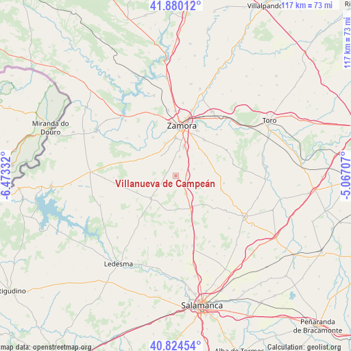
Villanueva de Campeán GPS coordinates[2]
41° 21' 16.092" North, 5° 46' 12.72" West
| Map corner | latitude | longitude |
|---|---|---|
| Upper-left | 41.88012°, | -6.47332° |
| Center: | 41.35447°, | -5.7702° |
| Lower-right: | 40.82454°, | -5.06707° |
| Map W x H: | 117.4×117.4 km | = 72.9×72.9mi |
| max Lat: | 43.74134° ⇑43.6% North |
| Villanueva de Campeán: | 41.35447° |
| min Lat: | ⇓56.4% South 27.64134° |
| min Long | Villanueva de C | max Long |
| -18.00367° | -5.7702° | 4.2899° |
| W 17.1%⇐ | ⇒82.9% E |
Elevation
Elevation of Villanueva de Campeán is 760 m = 2493 ft, and this is 162 m = 531 ft above average elevation for this country.
| Max E: |
1682 m = 5518 ft | 37.6% |
| Villanueva de Campeán | 760 m 2493 ft | |
| Avg. | 598 m = 1962 ft | |
Min E: |
0 m = 0 ft | 62.4% |
See also: Spain elevation on elevation.city.
Geographical zone
Villanueva de Campeán is located in North temperate zone (between Tropic of Cancer and the Arctic Circle). Distance of this Northern Tropic circle is 1992.3 km =1238 mi to South.| Distance of | km | miles | from Villanueva de Campeán |
|---|---|---|---|
| North Pole | 5408.9 | 3360.9 | to North |
| Arctic Circle | 2803 | 1741.7 | to North |
| Tropic Cancer | 1992.3 | 1238 | to South |
| Equator | 4598.2 | 2857.2 | to South |


Nearby cities:
15 places around Villanueva de Campeán: (largest is in red/bold)
• Cabañas de Sayago
2.6 km =1.6 mi,  204°
204°
• Casaseca de Campeán
3 km =1.9 mi,  41°
41°
• Casaseca de las Chanas
12.3 km =7.6 mi, 40°
• Cazurra
8.7 km =5.4 mi, 38°
• Corrales
3.8 km =2.4 mi,  84°
84°
• Cuelgamures
10.8 km =6.7 mi,  119°
119°
• El Perdigón
6.6 km =4.1 mi,  12°
12°
• Entrala
8.5 km =5.3 mi, 8°
• Jambrina
9.8 km =6.1 mi,  64°
64°
• Mayalde
11.8 km =7.3 mi,  191°
191°
• Morales del Vino
10.8 km =6.7 mi,  17°
17°
• Peleas de Abajo
7.9 km =4.9 mi, 57°
• Pereruela
11.3 km =7 mi,  307°
307°
• Peñausende
11.1 km =6.9 mi,  227°
227°
• Santa Clara de Avedillo
8 km =5 mi,  102°
102°
Sources, notices
• [Note1] Compared only with cities in Spain existing in our database
• [Src1] Map data: © OpenStreetMap contributors (CC-BY-SA)
• [Src2] Other city data from geonames.org with taken over terms of usage.
• [Src3] Geographical zone / Annual Mean Temperature by Robert A. Rohde @ Wikipedia
