Destriana geodata
Destriana (Castille and León) is a seat of a third-order administrative division; located in Spain in Europe/Madrid (GMT+2) time zone. With population of 712 people, there are 3382 cities with bigger population in this country. Compared to other cities in Spain, 82.6% of cities are located further ↓South; 87.3% of cities are located further →East and 79% of cities have lower elevation than Destriana. Note1
Administrative division(s):
- Level 1: Castille and León
- Level 2: Provincia de León
- Level 3: Destriana


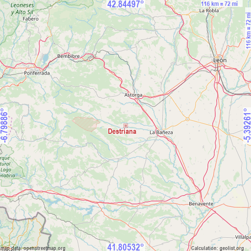
Destriana GPS coordinates[2]
42° 19' 38.244" North, 6° 5' 44.628" West
| Map corner | latitude | longitude |
|---|---|---|
| Upper-left | 42.84497°, | -6.79886° |
| Center: | 42.32729°, | -6.09573° |
| Lower-right: | 41.80532°, | -5.39261° |
| Map W x H: | 115.6×115.6 km | = 71.8×71.8mi |
| max Lat: | 43.74134° ⇑17.4% North |
| Destriana: | 42.32729° |
| min Lat: | ⇓82.6% South 27.64134° |
| min Long | Destriana | max Long |
| -18.00367° | -6.09573° | 4.2899° |
| W 12.7%⇐ | ⇒87.3% E |
Elevation
Elevation of Destriana is 889 m = 2917 ft, and this is 291 m = 955 ft above average elevation for this country.
| Max E: |
1682 m = 5518 ft | 21% |
| Destriana | 889 m 2917 ft | |
| Avg. | 598 m = 1962 ft | |
Min E: |
0 m = 0 ft | 79% |
See also: Spain elevation on elevation.city.
Geographical zone
Destriana is located in North temperate zone (between Tropic of Cancer and the Arctic Circle). Distance of this Northern Tropic circle is 2100.4 km =1305.1 mi to South.| Distance of | km | miles | from Destriana |
|---|---|---|---|
| North Pole | 5300.7 | 3293.7 | to North |
| Arctic Circle | 2694.8 | 1674.5 | to North |
| Tropic Cancer | 2100.4 | 1305.1 | to South |
| Equator | 4706.4 | 2924.4 | to South |


Nearby cities:
15 places around Destriana: (largest is in red/bold)
• Astorga
15 km =9.3 mi,  12°
12°
• Castrillo de la Valduerna
3.2 km =2 mi,  263°
263°
• Castrocalbón
17.2 km =10.7 mi,  147°
147°
• La Bañeza
16.6 km =10.3 mi,  100°
100°
• Luyego
12.1 km =7.5 mi,  291°
291°
• Palacios de la Valduerna
12.9 km =8 mi,  89°
89°
• Quintana y Congosto
9.3 km =5.8 mi, 148°
• Riego de la Vega
11.8 km =7.3 mi,  52°
52°
• San Cristóbal de la Polantera
17 km =10.6 mi,  65°
65°
• San Justo de la Vega
15.8 km =9.8 mi,  23°
23°
• Santa María de la Isla
14.1 km =8.8 mi,  77°
77°
• Santiago Millas
6.3 km =3.9 mi,  352°
352°
• Val de San Lorenzo
10.4 km =6.5 mi, 347°
• Valderrey
9.6 km =6 mi,  39°
39°
• Villamontán de la Valduerna
8.4 km =5.2 mi, 103°
Sources, notices
• [Note1] Compared only with cities in Spain existing in our database
• [Src1] Map data: © OpenStreetMap contributors (CC-BY-SA)
• [Src2] Other city data from geonames.org with taken over terms of usage.
• [Src3] Geographical zone / Annual Mean Temperature by Robert A. Rohde @ Wikipedia
