Cubillos geodata
Cubillos (Castille and León) is a seat of a third-order administrative division; located in Spain in Europe/Madrid (GMT+2) time zone. With population of 392 people, there are 4164 cities with bigger population in this country. Compared to other cities in Spain, 62.7% of cities are located further ↓South; 82.3% of cities are located further →East and 51.1% of cities have lower elevation than Cubillos. Note1
Administrative division(s):
- Level 1: Castille and León
- Level 2: Provincia de Zamora
- Level 3: Cubillos


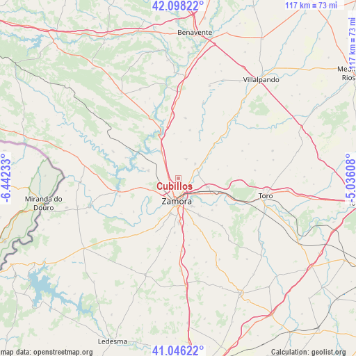
Cubillos GPS coordinates[2]
41° 34' 27.696" North, 5° 44' 21.12" West
| Map corner | latitude | longitude |
|---|---|---|
| Upper-left | 42.09822°, | -6.44233° |
| Center: | 41.57436°, | -5.7392° |
| Lower-right: | 41.04622°, | -5.03608° |
| Map W x H: | 117×117 km | = 72.7×72.7mi |
| max Lat: | 43.74134° ⇑37.3% North |
| Cubillos: | 41.57436° |
| min Lat: | ⇓62.7% South 27.64134° |
| min Long | Cubillos | max Long |
| -18.00367° | -5.7392° | 4.2899° |
| W 17.7%⇐ | ⇒82.3% E |
Elevation
Elevation of Cubillos is 670 m = 2198 ft, and this is 72 m = 236 ft above average elevation for this country.
| Max E: |
1682 m = 5518 ft | 48.9% |
| Cubillos | 670 m 2198 ft | |
| Avg. | 598 m = 1962 ft | |
Min E: |
0 m = 0 ft | 51.1% |
See also: Spain elevation on elevation.city.
Geographical zone
Cubillos is located in North temperate zone (between Tropic of Cancer and the Arctic Circle). Distance of this Northern Tropic circle is 2016.7 km =1253.1 mi to South.| Distance of | km | miles | from Cubillos |
|---|---|---|---|
| North Pole | 5384.4 | 3345.7 | to North |
| Arctic Circle | 2778.5 | 1726.5 | to North |
| Tropic Cancer | 2016.7 | 1253.1 | to South |
| Equator | 4622.6 | 2872.3 | to South |


Nearby cities:
15 places around Cubillos: (largest is in red/bold)
• Algodre
11.3 km =7 mi,  94°
94°
• Benegiles
10.5 km =6.5 mi,  56°
56°
• Coreses
10.1 km =6.3 mi,  106°
106°
• Gallegos del Pan
13.4 km =8.3 mi,  77°
77°
• Molacillos
6.6 km =4.1 mi, 81°
• Monfarracinos
3.4 km =2.1 mi,  130°
130°
• Montamarta
9.7 km =6 mi,  326°
326°
• Moreruela de los Infanzones
6.9 km =4.3 mi,  23°
23°
• Palacios del Pan
11.9 km =7.4 mi,  285°
285°
• Piedrahita de Castro
11.9 km =7.4 mi,  4°
4°
• Roales
3.7 km =2.3 mi,  227°
227°
• Torres del Carrizal
7.3 km =4.5 mi,  49°
49°
• Valcabado
3 km =1.9 mi,  196°
196°
• Villaralbo
10.2 km =6.3 mi,  153°
153°
• Zamora
7.6 km =4.7 mi,  183°
183°
Sources, notices
• [Note1] Compared only with cities in Spain existing in our database
• [Src1] Map data: © OpenStreetMap contributors (CC-BY-SA)
• [Src2] Other city data from geonames.org with taken over terms of usage.
• [Src3] Geographical zone / Annual Mean Temperature by Robert A. Rohde @ Wikipedia
