Algodre geodata
Algodre (Castille and León) is a seat of a third-order administrative division; located in Spain in Europe/Madrid (GMT+2) time zone. With population of 182 people, there are 5175 cities with bigger population in this country. Compared to other cities in Spain, 62.5% of cities are located further ↓South; 80.2% of cities are located further →East and 50.2% of cities have lower elevation than Algodre. Note1
Administrative division(s):
- Level 1: Castille and León
- Level 2: Provincia de Zamora
- Level 3: Algodre


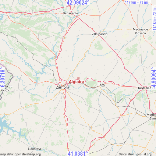
Algodre GPS coordinates[2]
41° 33' 58.716" North, 5° 36' 14.616" West
| Map corner | latitude | longitude |
|---|---|---|
| Upper-left | 42.09024°, | -6.30719° |
| Center: | 41.56631°, | -5.60406° |
| Lower-right: | 41.0381°, | -4.90094° |
| Map W x H: | 117×117 km | = 72.7×72.7mi |
| max Lat: | 43.74134° ⇑37.5% North |
| Algodre: | 41.56631° |
| min Lat: | ⇓62.5% South 27.64134° |
| min Long | Algodre | max Long |
| -18.00367° | -5.60406° | 4.2899° |
| W 19.8%⇐ | ⇒80.2% E |
Elevation
Elevation of Algodre is 660 m = 2165 ft, and this is 62 m = 203 ft above average elevation for this country.
| Max E: |
1682 m = 5518 ft | 49.8% |
| Algodre | 660 m 2165 ft | |
| Avg. | 598 m = 1962 ft | |
Min E: |
0 m = 0 ft | 50.2% |
See also: Spain elevation on elevation.city.
Geographical zone
Algodre is located in North temperate zone (between Tropic of Cancer and the Arctic Circle). Distance of this Northern Tropic circle is 2015.8 km =1252.6 mi to South.| Distance of | km | miles | from Algodre |
|---|---|---|---|
| North Pole | 5385.3 | 3346.3 | to North |
| Arctic Circle | 2779.4 | 1727 | to North |
| Tropic Cancer | 2015.8 | 1252.6 | to South |
| Equator | 4621.7 | 2871.8 | to South |


Nearby cities:
15 places around Algodre: (largest is in red/bold)
• Aspariegos
12 km =7.5 mi,  1°
1°
• Benegiles
7.2 km =4.5 mi,  339°
339°
• Coreses
2.6 km =1.6 mi,  216°
216°
• Cubillos
11.3 km =7 mi,  274°
274°
• Fresno de la Ribera
5.2 km =3.2 mi,  142°
142°
• Gallegos del Pan
4.2 km =2.6 mi,  27°
27°
• Madridanos
9.6 km =6 mi,  180°
180°
• Matilla la Seca
8.8 km =5.5 mi,  80°
80°
• Molacillos
5 km =3.1 mi,  291°
291°
• Monfarracinos
8.7 km =5.4 mi,  261°
261°
• Moreruela de los Infanzones
11.1 km =6.9 mi,  310°
310°
• Torres del Carrizal
8 km =5 mi,  315°
315°
• Villalazán
8.1 km =5 mi,  171°
171°
• Villalube
6.9 km =4.3 mi,  45°
45°
• Villaralbo
10.6 km =6.6 mi, 218°
Sources, notices
• [Note1] Compared only with cities in Spain existing in our database
• [Src1] Map data: © OpenStreetMap contributors (CC-BY-SA)
• [Src2] Other city data from geonames.org with taken over terms of usage.
• [Src3] Geographical zone / Annual Mean Temperature by Robert A. Rohde @ Wikipedia
