Bordils geodata
Bordils (Catalonia) is a seat of a third-order administrative division; located in Spain in Europe/Madrid (GMT+2) time zone. With population of 1,434 people, there are 2523 cities with bigger population in this country. Compared to other cities in Spain, 74.9% of cities are located further ↓South; 98.2% of cities are located further ←West and 91.9% of cities have higher elevation than Bordils. Note1


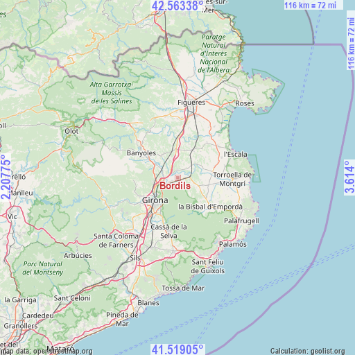
Bordils GPS coordinates[2]
42° 2' 36.096" North, 2° 54' 39.168" East
| Map corner | latitude | longitude |
|---|---|---|
| Upper-left | 42.56338°, | 2.20775° |
| Center: | 42.04336°, | 2.91088° |
| Lower-right: | 41.51905°, | 3.614° |
| Map W x H: | 116.1×116.1 km | = 72.1×72.1mi |
| max Lat: | 43.74134° ⇑25.1% North |
| Bordils: | 42.04336° |
| min Lat: | ⇓74.9% South 27.64134° |
| min Long | Bordils | max Long |
| -18.00367° | 2.91088° | 4.2899° |
| W 98.2%⇐ | ⇒1.8% E |
Elevation
Elevation of Bordils is 45 m = 148 ft, and this is 553 m = 1814 ft below average elevation for this country.
| Max E: |
1682 m = 5518 ft | 91.9% |
| Avg. | 598 m = 1962 ft | |
| Bordils | 45 m = 148 ft | |
Min E: |
0 m = 0 ft | 8.1% |
See also: Spain elevation on elevation.city.
Geographical zone
Bordils is located in North temperate zone (between Tropic of Cancer and the Arctic Circle). Distance of this Northern Tropic circle is 2068.9 km =1285.6 mi to South.| Distance of | km | miles | from Bordils |
|---|---|---|---|
| North Pole | 5332.3 | 3313.3 | to North |
| Arctic Circle | 2726.4 | 1694.1 | to North |
| Tropic Cancer | 2068.9 | 1285.6 | to South |
| Equator | 4674.8 | 2904.8 | to South |


Nearby cities:
15 places around Bordils: (largest is in red/bold)
• Celrà
2.5 km =1.6 mi,  243°
243°
• Cervià de Ter
2.6 km =1.6 mi,  353°
353°
• Colomers
7.5 km =4.7 mi,  53°
53°
• Cornellà del Terri
9 km =5.6 mi,  299°
299°
• Flaçà
5.3 km =3.3 mi,  60°
60°
• Foixà
7.4 km =4.6 mi,  96°
96°
• Jafre
8.9 km =5.5 mi,  68°
68°
• Juià
3 km =1.9 mi,  170°
170°
• Madremanya
8.1 km =5 mi,  145°
145°
• Sant Joan de Mollet
3.3 km =2.1 mi,  77°
77°
• Sant Jordi Desvalls
4.1 km =2.5 mi, 51°
• Sant Julià de Ramis
5 km =3.1 mi,  251°
251°
• Sant Martí Vell
3.5 km =2.2 mi, 148°
• Sarrià de Ter
7.1 km =4.4 mi, 245°
• Viladasens
4.8 km =3 mi,  22°
22°
Sources, notices
• [Note1] Compared only with cities in Spain existing in our database
• [Src1] Map data: © OpenStreetMap contributors (CC-BY-SA)
• [Src2] Other city data from geonames.org with taken over terms of usage.
• [Src3] Geographical zone / Annual Mean Temperature by Robert A. Rohde @ Wikipedia
