Celrà geodata
Celrà (Catalonia) is a seat of a third-order administrative division; located in Spain in Europe/Madrid (GMT+2) time zone. With population of 3,372 people, there are 1616 cities with bigger population in this country. Compared to other cities in Spain, 74.6% of cities are located further ↓South; 98% of cities are located further ←West and 90.8% of cities have higher elevation than Celrà. Note1


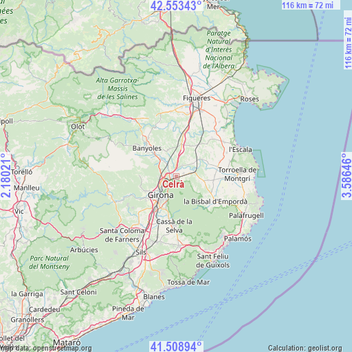
Celrà GPS coordinates[2]
42° 1' 59.988" North, 2° 52' 59.988" East
| Map corner | latitude | longitude |
|---|---|---|
| Upper-left | 42.55343°, | 2.18021° |
| Center: | 42.03333°, | 2.88333° |
| Lower-right: | 41.50894°, | 3.58646° |
| Map W x H: | 116.1×116.1 km | = 72.1×72.1mi |
| max Lat: | 43.74134° ⇑25.4% North |
| Celrà: | 42.03333° |
| min Lat: | ⇓74.6% South 27.64134° |
| min Long | Celrà | max Long |
| -18.00367° | 2.88333° | 4.2899° |
| W 98%⇐ | ⇒2% E |
Elevation
Elevation of Celrà is 54 m = 177 ft, and this is 544 m = 1785 ft below average elevation for this country.
| Max E: |
1682 m = 5518 ft | 90.8% |
| Avg. | 598 m = 1962 ft | |
| Celrà | 54 m = 177 ft | |
Min E: |
0 m = 0 ft | 9.2% |
See also: Spain elevation on elevation.city.
Geographical zone
Celrà is located in North temperate zone (between Tropic of Cancer and the Arctic Circle). Distance of this Northern Tropic circle is 2067.7 km =1284.8 mi to South.| Distance of | km | miles | from Celrà |
|---|---|---|---|
| North Pole | 5333.4 | 3314 | to North |
| Arctic Circle | 2727.5 | 1694.8 | to North |
| Tropic Cancer | 2067.7 | 1284.8 | to South |
| Equator | 4673.7 | 2904.1 | to South |


Nearby cities:
15 places around Celrà: (largest is in red/bold)
• Bordils
2.5 km =1.6 mi,  63°
63°
• Cervià de Ter
4.2 km =2.6 mi,  28°
28°
• Cornellà del Terri
7.8 km =4.8 mi,  315°
315°
• Flaçà
7.8 km =4.8 mi, 61°
• Foixà
9.7 km =6 mi,  88°
88°
• Girona
7.4 km =4.6 mi,  220°
220°
• Juià
3.3 km =2.1 mi,  123°
123°
• Madremanya
8.8 km =5.5 mi,  128°
128°
• Palol de Revardit
7.8 km =4.8 mi,  298°
298°
• Sant Joan de Mollet
5.8 km =3.6 mi,  71°
71°
• Sant Jordi Desvalls
6.6 km =4.1 mi, 56°
• Sant Julià de Ramis
2.5 km =1.6 mi,  259°
259°
• Sant Martí Vell
4.5 km =2.8 mi,  114°
114°
• Sarrià de Ter
4.5 km =2.8 mi,  245°
245°
• Viladasens
6.9 km =4.3 mi,  36°
36°
Sources, notices
• [Note1] Compared only with cities in Spain existing in our database
• [Src1] Map data: © OpenStreetMap contributors (CC-BY-SA)
• [Src2] Other city data from geonames.org with taken over terms of usage.
• [Src3] Geographical zone / Annual Mean Temperature by Robert A. Rohde @ Wikipedia
