Berrueces geodata
Berrueces (Castille and León) is a seat of a third-order administrative division; located in Spain in Europe/Madrid (GMT+2) time zone. With population of 102 people, there are 5908 cities with bigger population in this country. Compared to other cities in Spain, 72.1% of cities are located further ↓South; 73.7% of cities are located further →East and 64.1% of cities have lower elevation than Berrueces. Note1
Administrative division(s):
- Level 1: Castille and León
- Level 2: Provincia de Valladolid
- Level 3: Berrueces


Berrueces GPS coordinates[2]
41° 56' 45.816" North, 5° 5' 48.948" West
| Map corner | latitude | longitude |
|---|---|---|
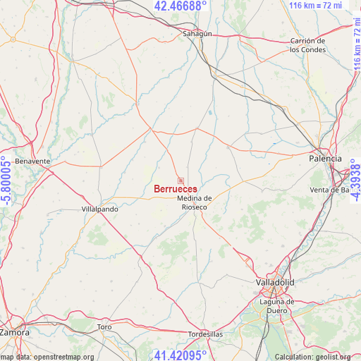
| Upper-left | 42.46688°, | -5.80005° |
| Center: | 41.94606°, | -5.09693° |
| Lower-right: | 41.42095°, | -4.3938° |
| Map W x H: | 116.3×116.3 km | = 72.3×72.3mi |
| max Lat: | 43.74134° ⇑27.9% North |
| Berrueces: | 41.94606° |
| min Lat: | ⇓72.1% South 27.64134° |
| min Long | Berrueces | max Long |
| -18.00367° | -5.09693° | 4.2899° |
| W 26.3%⇐ | ⇒73.7% E |
Elevation
Elevation of Berrueces is 772 m = 2533 ft, and this is 174 m = 571 ft above average elevation for this country.
| Max E: |
1682 m = 5518 ft | 35.9% |
| Berrueces | 772 m 2533 ft | |
| Avg. | 598 m = 1962 ft | |
Min E: |
0 m = 0 ft | 64.1% |
See also: Spain elevation on elevation.city.
Geographical zone
Berrueces is located in North temperate zone (between Tropic of Cancer and the Arctic Circle). Distance of this Northern Tropic circle is 2058 km =1278.8 mi to South.| Distance of | km | miles | from Berrueces |
|---|---|---|---|
| North Pole | 5343.1 | 3320 | to North |
| Arctic Circle | 2737.2 | 1700.8 | to North |
| Tropic Cancer | 2058 | 1278.8 | to South |
| Equator | 4664 | 2898.1 | to South |


Nearby cities:
15 places around Berrueces: (largest is in red/bold)
• Aguilar de Campos
8.1 km =5 mi,  301°
301°
• Belmonte de Campos
9.1 km =5.7 mi,  92°
92°
• Castil de Vela
12.2 km =7.6 mi,  69°
69°
• Ceinos de Campos
10.6 km =6.6 mi,  335°
335°
• Cuenca de Campos
13 km =8.1 mi,  15°
15°
• Medina de Ríoseco
8.2 km =5.1 mi,  147°
147°
• Moral de la Reina
4.9 km =3 mi, 24°
• Morales de Campos
11.4 km =7.1 mi,  213°
213°
• Palazuelo de Vedija
4.4 km =2.7 mi,  245°
245°
• Tamariz de Campos
7 km =4.3 mi,  60°
60°
• Valverde de Campos
13.3 km =8.3 mi,  158°
158°
• Villabaruz de Campos
11 km =6.8 mi,  49°
49°
• Villafrechós
11.7 km =7.3 mi,  239°
239°
• Villamuriel de Campos
9.1 km =5.7 mi,  270°
270°
• Villanueva de San Mancio
7.3 km =4.5 mi,  105°
105°
Sources, notices
• [Note1] Compared only with cities in Spain existing in our database
• [Src1] Map data: © OpenStreetMap contributors (CC-BY-SA)
• [Src2] Other city data from geonames.org with taken over terms of usage.
• [Src3] Geographical zone / Annual Mean Temperature by Robert A. Rohde @ Wikipedia
