Bea geodata
Bea (Aragon) is a seat of a third-order administrative division; located in Spain in Europe/Madrid (GMT+2) time zone. With population of 39 people, there are 6576 cities with bigger population in this country. Compared to other cities in Spain, 50.7% of cities are located further ↑North; 76% of cities are located further ←West and 94.6% of cities have lower elevation than Bea. Note1


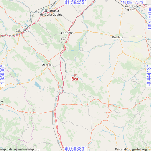
Bea GPS coordinates[2]
41° 2' 10.788" North, 1° 8' 50.1" West
| Map corner | latitude | longitude |
|---|---|---|
| Upper-left | 41.56455°, | -1.85038° |
| Center: | 41.03633°, | -1.14725° |
| Lower-right: | 40.50383°, | -0.44413° |
| Map W x H: | 117.9×117.9 km | = 73.3×73.3mi |
| max Lat: | 43.74134° ⇑50.7% North |
| Bea: | 41.03633° |
| min Lat: | ⇓49.3% South 27.64134° |
| min Long | Bea | max Long |
| -18.00367° | -1.14725° | 4.2899° |
| W 76%⇐ | ⇒24% E |
Elevation
Elevation of Bea is 1127 m = 3698 ft, and this is 529 m = 1736 ft above average elevation for this country.
| Max E: |
1682 m = 5518 ft | 5.4% |
| Bea | 1127 m 3698 ft | |
| Avg. | 598 m = 1962 ft | |
Min E: |
0 m = 0 ft | 94.6% |
See also: Spain elevation on elevation.city.
Geographical zone
Bea is located in North temperate zone (between Tropic of Cancer and the Arctic Circle). Distance of this Northern Tropic circle is 1956.9 km =1216 mi to South.| Distance of | km | miles | from Bea |
|---|---|---|---|
| North Pole | 5444.2 | 3382.9 | to North |
| Arctic Circle | 2838.4 | 1763.7 | to North |
| Tropic Cancer | 1956.9 | 1216 | to South |
| Equator | 4562.8 | 2835.2 | to South |


Nearby cities:
15 places around Bea: (largest is in red/bold)
• Allueva
10.5 km =6.5 mi,  122°
122°
• Bádenas
6.5 km =4 mi,  18°
18°
• Cucalón
7.9 km =4.9 mi,  314°
314°
• Ferreruela de Huerva
7.8 km =4.8 mi,  292°
292°
• Fombuena
12.6 km =7.8 mi,  342°
342°
• Fonfría
6.9 km =4.3 mi,  130°
130°
• Lagueruela
3.9 km =2.4 mi,  280°
280°
• Lanzuela
8.5 km =5.3 mi,  324°
324°
• Lechón
12.8 km =8 mi,  295°
295°
• Loscos
10 km =6.2 mi,  60°
60°
• Luesma
14.4 km =8.9 mi,  0°
0°
• Monforte de Moyuela
11.4 km =7.1 mi,  79°
79°
• Nogueras
12.8 km =8 mi,  31°
31°
• Santa Cruz de Nogueras
10 km =6.2 mi, 29°
• Villahermosa del Campo
11.7 km =7.3 mi, 314°
Sources, notices
• [Note1] Compared only with cities in Spain existing in our database
• [Src1] Map data: © OpenStreetMap contributors (CC-BY-SA)
• [Src2] Other city data from geonames.org with taken over terms of usage.
• [Src3] Geographical zone / Annual Mean Temperature by Robert A. Rohde @ Wikipedia
