Allueva geodata
Allueva (Aragon) is a seat of a third-order administrative division; located in Spain in Europe/Madrid (GMT+2) time zone. With population of 12 people, there are 6754 cities with bigger population in this country. Compared to other cities in Spain, 51.9% of cities are located further ↑North; 76.8% of cities are located further ←West and 96.7% of cities have lower elevation than Allueva. Note1


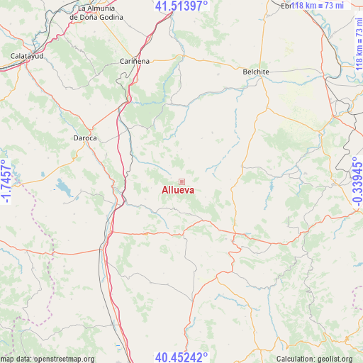
Allueva GPS coordinates[2]
40° 59' 7.188" North, 1° 2' 33.288" West
| Map corner | latitude | longitude |
|---|---|---|
| Upper-left | 41.51397°, | -1.7457° |
| Center: | 40.98533°, | -1.04258° |
| Lower-right: | 40.45242°, | -0.33945° |
| Map W x H: | 118×118 km | = 73.3×73.3mi |
| max Lat: | 43.74134° ⇑51.9% North |
| Allueva: | 40.98533° |
| min Lat: | ⇓48.1% South 27.64134° |
| min Long | Allueva | max Long |
| -18.00367° | -1.04258° | 4.2899° |
| W 76.8%⇐ | ⇒23.2% E |
Elevation
Elevation of Allueva is 1197 m = 3927 ft, and this is 599 m = 1965 ft above average elevation for this country.
| Max E: |
1682 m = 5518 ft | 3.3% |
| Allueva | 1197 m 3927 ft | |
| Avg. | 598 m = 1962 ft | |
Min E: |
0 m = 0 ft | 96.7% |
See also: Spain elevation on elevation.city.
Geographical zone
Allueva is located in North temperate zone (between Tropic of Cancer and the Arctic Circle). Distance of this Northern Tropic circle is 1951.2 km =1212.4 mi to South.| Distance of | km | miles | from Allueva |
|---|---|---|---|
| North Pole | 5449.9 | 3386.4 | to North |
| Arctic Circle | 2844 | 1767.2 | to North |
| Tropic Cancer | 1951.2 | 1212.4 | to South |
| Equator | 4557.1 | 2831.6 | to South |


Nearby cities:
15 places around Allueva: (largest is in red/bold)
• Anadón
5 km =3.1 mi,  93°
93°
• Barrachina
12.7 km =7.9 mi,  219°
219°
• Bea
10.5 km =6.5 mi,  302°
302°
• Bádenas
13.6 km =8.5 mi,  330°
330°
• Fonfría
3.7 km =2.3 mi,  287°
287°
• Fuenferrada
13.2 km =8.2 mi,  168°
168°
• Huesa del Común
10.8 km =6.7 mi,  74°
74°
• Lagueruela
14.1 km =8.8 mi, 296°
• Loscos
10.6 km =6.6 mi,  359°
359°
• Maicas
12.9 km =8 mi,  99°
99°
• Monforte de Moyuela
8.1 km =5 mi,  17°
17°
• Salcedillo
4.1 km =2.5 mi,  128°
128°
• Segura de los Baños
9.1 km =5.7 mi,  122°
122°
• Torrecilla del Rebollar
8.8 km =5.5 mi,  196°
196°
• Villanueva del Rebollar de la Sierra
10.9 km =6.8 mi,  164°
164°
Sources, notices
• [Note1] Compared only with cities in Spain existing in our database
• [Src1] Map data: © OpenStreetMap contributors (CC-BY-SA)
• [Src2] Other city data from geonames.org with taken over terms of usage.
• [Src3] Geographical zone / Annual Mean Temperature by Robert A. Rohde @ Wikipedia
