Basardilla geodata
Basardilla (Castille and León) is a seat of a third-order administrative division; located in Spain in Europe/Madrid (GMT+2) time zone. With population of 176 people, there are 5212 cities with bigger population in this country. Compared to other cities in Spain, 51% of cities are located further ↑North; 60.2% of cities are located further →East and 93.1% of cities have lower elevation than Basardilla. Note1
Administrative division(s):
- Level 1: Castille and León
- Level 2: Provincia de Segovia
- Level 3: Basardilla


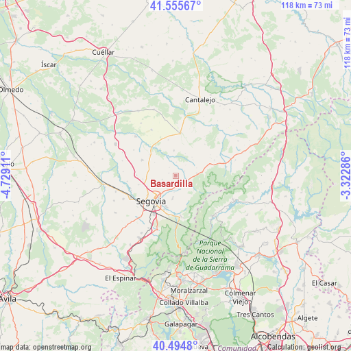
Basardilla GPS coordinates[2]
41° 1' 38.532" North, 4° 1' 33.528" West
| Map corner | latitude | longitude |
|---|---|---|
| Upper-left | 41.55567°, | -4.72911° |
| Center: | 41.02737°, | -4.02598° |
| Lower-right: | 40.4948°, | -3.32286° |
| Map W x H: | 118×118 km | = 73.3×73.3mi |
| max Lat: | 43.74134° ⇑51% North |
| Basardilla: | 41.02737° |
| min Lat: | ⇓49% South 27.64134° |
| min Long | Basardilla | max Long |
| -18.00367° | -4.02598° | 4.2899° |
| W 39.8%⇐ | ⇒60.2% E |
Elevation
Elevation of Basardilla is 1094 m = 3589 ft, and this is 496 m = 1627 ft above average elevation for this country.
| Max E: |
1682 m = 5518 ft | 6.9% |
| Basardilla | 1094 m 3589 ft | |
| Avg. | 598 m = 1962 ft | |
Min E: |
0 m = 0 ft | 93.1% |
See also: Spain elevation on elevation.city.
Geographical zone
Basardilla is located in North temperate zone (between Tropic of Cancer and the Arctic Circle). Distance of this Northern Tropic circle is 1955.9 km =1215.3 mi to South.| Distance of | km | miles | from Basardilla |
|---|---|---|---|
| North Pole | 5445.2 | 3383.5 | to North |
| Arctic Circle | 2839.4 | 1764.3 | to North |
| Tropic Cancer | 1955.9 | 1215.3 | to South |
| Equator | 4561.8 | 2834.6 | to South |


Nearby cities:
15 places around Basardilla: (largest is in red/bold)
• Adrada de Pirón
3.5 km =2.2 mi,  323°
323°
• Brieva
2.5 km =1.6 mi,  289°
289°
• Cabañas de Polendos
8.3 km =5.2 mi,  301°
301°
• Collado Hermoso
9.1 km =5.7 mi,  82°
82°
• Encinillas
11.1 km =6.9 mi,  264°
264°
• Espirdo
5.2 km =3.2 mi,  230°
230°
• La Cuesta
8.3 km =5.2 mi,  41°
41°
• La Lastrilla
9.3 km =5.8 mi, 225°
• Pelayos del Arroyo
7.6 km =4.7 mi,  69°
69°
• San Cristóbal de Segovia
9.4 km =5.8 mi,  206°
206°
• Santo Domingo de Pirón
3.4 km =2.1 mi,  63°
63°
• Sotosalbos
7.2 km =4.5 mi, 82°
• Torrecaballeros
3.9 km =2.4 mi,  178°
178°
• Torreiglesias
8.4 km =5.2 mi,  356°
356°
• Trescasas
7 km =4.3 mi,  186°
186°
Sources, notices
• [Note1] Compared only with cities in Spain existing in our database
• [Src1] Map data: © OpenStreetMap contributors (CC-BY-SA)
• [Src2] Other city data from geonames.org with taken over terms of usage.
• [Src3] Geographical zone / Annual Mean Temperature by Robert A. Rohde @ Wikipedia
