Argentona geodata
Argentona (Catalonia) is a seat of a third-order administrative division; located in Spain in Europe/Madrid (GMT+2) time zone. With population of 11,633 people, there are 762 cities with bigger population in this country. Compared to other cities in Spain, 62.3% of cities are located further ↓South; 96.2% of cities are located further ←West and 88.7% of cities have higher elevation than Argentona. Note1


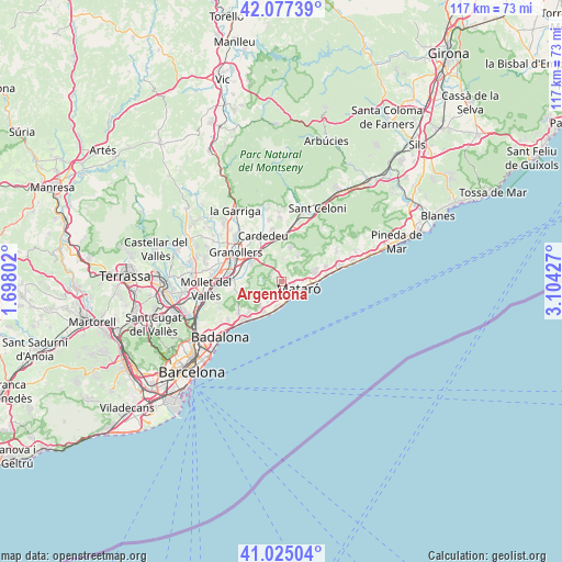
Argentona GPS coordinates[2]
41° 33' 12.096" North, 2° 24' 4.104" East
| Map corner | latitude | longitude |
|---|---|---|
| Upper-left | 42.07739°, | 1.69802° |
| Center: | 41.55336°, | 2.40114° |
| Lower-right: | 41.02504°, | 3.10427° |
| Map W x H: | 117×117 km | = 72.7×72.7mi |
| max Lat: | 43.74134° ⇑37.7% North |
| Argentona: | 41.55336° |
| min Lat: | ⇓62.3% South 27.64134° |
| min Long | Argentona | max Long |
| -18.00367° | 2.40114° | 4.2899° |
| W 96.2%⇐ | ⇒3.8% E |
Elevation
Elevation of Argentona is 85 m = 279 ft, and this is 513 m = 1683 ft below average elevation for this country.
| Max E: |
1682 m = 5518 ft | 88.7% |
| Avg. | 598 m = 1962 ft | |
| Argentona | 85 m = 279 ft | |
Min E: |
0 m = 0 ft | 11.3% |
See also: Spain elevation on elevation.city.
Geographical zone
Argentona is located in North temperate zone (between Tropic of Cancer and the Arctic Circle). Distance of this Northern Tropic circle is 2014.4 km =1251.7 mi to South.| Distance of | km | miles | from Argentona |
|---|---|---|---|
| North Pole | 5386.8 | 3347.2 | to North |
| Arctic Circle | 2780.9 | 1728 | to North |
| Tropic Cancer | 2014.4 | 1251.7 | to South |
| Equator | 4620.3 | 2870.9 | to South |


Nearby cities:
15 places around Argentona: (largest is in red/bold)
• Cabrera de Mar
4.1 km =2.5 mi,  181°
181°
• Cabrils
3.9 km =2.4 mi,  222°
222°
• Cardedeu
10.3 km =6.4 mi,  339°
339°
• Dosrius
3.6 km =2.2 mi,  21°
21°
• El Masnou
10.7 km =6.6 mi, 219°
• La Roca del Vallès
6.6 km =4.1 mi,  300°
300°
• Llinars del Vallès
8.9 km =5.5 mi,  359°
359°
• Mataró
3.8 km =2.4 mi,  109°
109°
• Premià de Mar
7.4 km =4.6 mi,  203°
203°
• Sant Andreu de Llavaneres
7 km =4.3 mi,  77°
77°
• Sant Vicenç de Montalt
9.4 km =5.8 mi,  72°
72°
• Teià
9 km =5.6 mi,  226°
226°
• Vallromanes
8.7 km =5.4 mi,  255°
255°
• Vilassar de Mar
5.4 km =3.4 mi,  187°
187°
• Òrrius
4.3 km =2.7 mi, 264°
Sources, notices
• [Note1] Compared only with cities in Spain existing in our database
• [Src1] Map data: © OpenStreetMap contributors (CC-BY-SA)
• [Src2] Other city data from geonames.org with taken over terms of usage.
• [Src3] Geographical zone / Annual Mean Temperature by Robert A. Rohde @ Wikipedia
