Cardedeu geodata
Cardedeu (Catalonia) is a populated place; located in Spain in Europe/Madrid (GMT+2) time zone. With population of 16,596 people, there are 566 cities with bigger population in this country. Compared to other cities in Spain, 64.5% of cities are located further ↓South; 96% of cities are located further ←West and 81.2% of cities have higher elevation than Cardedeu. Note1
Administrative division(s):
- Level 1: Catalonia
- Level 2: Província de Barcelona
- Level 3: la Roca del Vallès


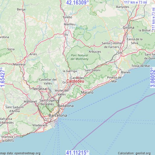
Cardedeu GPS coordinates[2]
41° 38' 23.136" North, 2° 21' 26.604" East
| Map corner | latitude | longitude |
|---|---|---|
| Upper-left | 42.16309°, | 1.65427° |
| Center: | 41.63976°, | 2.35739° |
| Lower-right: | 41.11215°, | 3.06052° |
| Map W x H: | 116.9×116.9 km | = 72.6×72.6mi |
| max Lat: | 43.74134° ⇑35.5% North |
| Cardedeu: | 41.63976° |
| min Lat: | ⇓64.5% South 27.64134° |
| min Long | Cardedeu | max Long |
| -18.00367° | 2.35739° | 4.2899° |
| W 96%⇐ | ⇒4% E |
Elevation
Elevation of Cardedeu is 199 m = 653 ft, and this is 399 m = 1309 ft below average elevation for this country.
| Max E: |
1682 m = 5518 ft | 81.2% |
| Avg. | 598 m = 1962 ft | |
| Cardedeu | 199 m = 653 ft | |
Min E: |
0 m = 0 ft | 18.8% |
See also: Spain elevation on elevation.city.
Geographical zone
Cardedeu is located in North temperate zone (between Tropic of Cancer and the Arctic Circle). Distance of this Northern Tropic circle is 2024 km =1257.7 mi to South.| Distance of | km | miles | from Cardedeu |
|---|---|---|---|
| North Pole | 5377.2 | 3341.2 | to North |
| Arctic Circle | 2771.3 | 1722 | to North |
| Tropic Cancer | 2024 | 1257.7 | to South |
| Equator | 4629.9 | 2876.9 | to South |


Nearby cities:
15 places around Cardedeu: (largest is in red/bold)
• Argentona
10.3 km =6.4 mi,  159°
159°
• Canovelles
6.7 km =4.2 mi,  247°
247°
• Cànoves i Samalús
4.9 km =3 mi,  352°
352°
• Dosrius
8 km =5 mi,  141°
141°
• Granollers
6.8 km =4.2 mi,  238°
238°
• L'Ametlla del Vallès
8.1 km =5 mi,  291°
291°
• La Roca del Vallès
6.6 km =4.1 mi,  197°
197°
• Les Franqueses del Vallès
5.4 km =3.4 mi, 245°
• Llinars del Vallès
3.6 km =2.2 mi,  101°
101°
• Lliçà d'Amunt
10.6 km =6.6 mi,  256°
256°
• Sant Pere de Vilamajor
5.3 km =3.3 mi,  23°
23°
• Santa Eulàlia de Ronçana
10.4 km =6.5 mi,  276°
276°
• Santa Maria de Palautordera
9.5 km =5.9 mi,  50°
50°
• la Garriga
7.8 km =4.8 mi,  308°
308°
• Òrrius
10 km =6.2 mi,  183°
183°
Sources, notices
• [Note1] Compared only with cities in Spain existing in our database
• [Src1] Map data: © OpenStreetMap contributors (CC-BY-SA)
• [Src2] Other city data from geonames.org with taken over terms of usage.
• [Src3] Geographical zone / Annual Mean Temperature by Robert A. Rohde @ Wikipedia
