Albiztur geodata
Albiztur (Basque Country) is a seat of a third-order administrative division; located in Spain in Europe/Madrid (GMT+2) time zone. With population of 299 people, there are 4508 cities with bigger population in this country. Compared to other cities in Spain, 95.5% of cities are located further ↓South; 65.7% of cities are located further ←West and 76.4% of cities have higher elevation than Albiztur. Note1


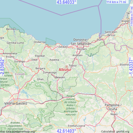
Albiztur GPS coordinates[2]
43° 7' 45.588" North, 2° 8' 11.364" West
| Map corner | latitude | longitude |
|---|---|---|
| Upper-left | 43.64033°, | -2.83962° |
| Center: | 43.12933°, | -2.13649° |
| Lower-right: | 42.61403°, | -1.43337° |
| Map W x H: | 114.1×114.1 km | = 70.9×70.9mi |
| max Lat: | 43.74134° ⇑4.5% North |
| Albiztur: | 43.12933° |
| min Lat: | ⇓95.5% South 27.64134° |
| min Long | Albiztur | max Long |
| -18.00367° | -2.13649° | 4.2899° |
| W 65.7%⇐ | ⇒34.3% E |
Elevation
Elevation of Albiztur is 280 m = 919 ft, and this is 318 m = 1043 ft below average elevation for this country.
| Max E: |
1682 m = 5518 ft | 76.4% |
| Avg. | 598 m = 1962 ft | |
| Albiztur | 280 m = 919 ft | |
Min E: |
0 m = 0 ft | 23.6% |
See also: Spain elevation on elevation.city.
Geographical zone
Albiztur is located in North temperate zone (between Tropic of Cancer and the Arctic Circle). Distance of this Northern Tropic circle is 2189.6 km =1360.6 mi to South.| Distance of | km | miles | from Albiztur |
|---|---|---|---|
| North Pole | 5211.5 | 3238.3 | to North |
| Arctic Circle | 2605.6 | 1619 | to North |
| Tropic Cancer | 2189.6 | 1360.6 | to South |
| Equator | 4795.5 | 2979.8 | to South |


Nearby cities:
15 places around Albiztur: (largest is in red/bold)
• Alegia
4.5 km =2.8 mi,  134°
134°
• Alkiza
5.3 km =3.3 mi,  24°
24°
• Anoeta
6.5 km =4 mi,  55°
55°
• Baliarrain
6.7 km =4.2 mi,  173°
173°
• Beizama
5.2 km =3.2 mi,  275°
275°
• Belauntza
6.9 km =4.3 mi,  83°
83°
• Errezil
5 km =3.1 mi,  322°
322°
• Hernialde
5 km =3.1 mi, 56°
• Ibarra
5.8 km =3.6 mi,  87°
87°
• Ikaztegieta
4 km =2.5 mi, 165°
• Irura
7 km =4.3 mi,  53°
53°
• Leaburu
6.7 km =4.2 mi,  97°
97°
• Legorreta
5.1 km =3.2 mi,  192°
192°
• Orendain
5.9 km =3.7 mi,  160°
160°
• Tolosa
4.8 km =3 mi, 82°
Sources, notices
• [Note1] Compared only with cities in Spain existing in our database
• [Src1] Map data: © OpenStreetMap contributors (CC-BY-SA)
• [Src2] Other city data from geonames.org with taken over terms of usage.
• [Src3] Geographical zone / Annual Mean Temperature by Robert A. Rohde @ Wikipedia
