Orendain geodata
Orendain (Basque Country) is a seat of a third-order administrative division; located in Spain in Europe/Madrid (GMT+2) time zone. With population of 164 people, there are 5316 cities with bigger population in this country. Compared to other cities in Spain, 95% of cities are located further ↓South; 65.9% of cities are located further ←West and 70.3% of cities have higher elevation than Orendain. Note1


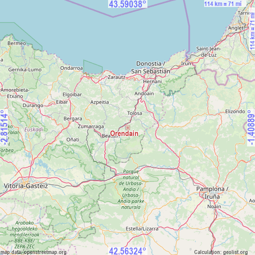
Orendain GPS coordinates[2]
43° 4' 44.256" North, 2° 6' 43.236" West
| Map corner | latitude | longitude |
|---|---|---|
| Upper-left | 43.59038°, | -2.81514° |
| Center: | 43.07896°, | -2.11201° |
| Lower-right: | 42.56324°, | -1.40889° |
| Map W x H: | 114.2×114.2 km | = 71×71mi |
| max Lat: | 43.74134° ⇑5% North |
| Orendain: | 43.07896° |
| min Lat: | ⇓95% South 27.64134° |
| min Long | Orendain | max Long |
| -18.00367° | -2.11201° | 4.2899° |
| W 65.9%⇐ | ⇒34.1% E |
Elevation
Elevation of Orendain is 376 m = 1234 ft, and this is 222 m = 728 ft below average elevation for this country.
| Max E: |
1682 m = 5518 ft | 70.3% |
| Avg. | 598 m = 1962 ft | |
| Orendain | 376 m = 1234 ft | |
Min E: |
0 m = 0 ft | 29.7% |
See also: Spain elevation on elevation.city.
Geographical zone
Orendain is located in North temperate zone (between Tropic of Cancer and the Arctic Circle). Distance of this Northern Tropic circle is 2184 km =1357.1 mi to South.| Distance of | km | miles | from Orendain |
|---|---|---|---|
| North Pole | 5217.1 | 3241.8 | to North |
| Arctic Circle | 2611.2 | 1622.5 | to North |
| Tropic Cancer | 2184 | 1357.1 | to South |
| Equator | 4789.9 | 2976.3 | to South |


Nearby cities:
15 places around Orendain: (largest is in red/bold)
• Abaltzisketa
3.5 km =2.2 mi,  171°
171°
• Albiztur
5.9 km =3.7 mi,  340°
340°
• Alegia
2.8 km =1.7 mi,  27°
27°
• Altzaga
3.8 km =2.4 mi,  245°
245°
• Amezketa
4.1 km =2.5 mi,  147°
147°
• Arama
4.7 km =2.9 mi, 248°
• Baliarrain
1.7 km =1.1 mi,  230°
230°
• Gaintza
3.4 km =2.1 mi,  210°
210°
• Ikaztegieta
2 km =1.2 mi,  331°
331°
• Itsasondo
4.4 km =2.7 mi,  255°
255°
• Leaburu
6.7 km =4.2 mi,  44°
44°
• Legorreta
3.2 km =2 mi,  281°
281°
• Ordizia
5.9 km =3.7 mi,  242°
242°
• Tolosa
6.8 km =4.2 mi,  23°
23°
• Zaldibia
5.6 km =3.5 mi, 214°
Sources, notices
• [Note1] Compared only with cities in Spain existing in our database
• [Src1] Map data: © OpenStreetMap contributors (CC-BY-SA)
• [Src2] Other city data from geonames.org with taken over terms of usage.
• [Src3] Geographical zone / Annual Mean Temperature by Robert A. Rohde @ Wikipedia
