Agón geodata
Agón (Aragon) is a seat of a third-order administrative division; located in Spain in Europe/Madrid (GMT+2) time zone. With population of 191 people, there are 5099 cities with bigger population in this country. Compared to other cities in Spain, 69.9% of cities are located further ↓South; 73.4% of cities are located further ←West and 73.5% of cities have higher elevation than Agón. Note1


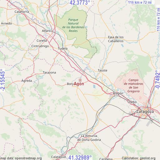
Agón GPS coordinates[2]
41° 51' 20.664" North, 1° 27' 8.388" West
| Map corner | latitude | longitude |
|---|---|---|
| Upper-left | 42.3773°, | -2.15545° |
| Center: | 41.85574°, | -1.45233° |
| Lower-right: | 41.32989°, | -0.7492° |
| Map W x H: | 116.5×116.5 km | = 72.4×72.4mi |
| max Lat: | 43.74134° ⇑30.1% North |
| Agón: | 41.85574° |
| min Lat: | ⇓69.9% South 27.64134° |
| min Long | Agón | max Long |
| -18.00367° | -1.45233° | 4.2899° |
| W 73.4%⇐ | ⇒26.6% E |
Elevation
Elevation of Agón is 324 m = 1063 ft, and this is 274 m = 899 ft below average elevation for this country.
| Max E: |
1682 m = 5518 ft | 73.5% |
| Avg. | 598 m = 1962 ft | |
| Agón | 324 m = 1063 ft | |
Min E: |
0 m = 0 ft | 26.5% |
See also: Spain elevation on elevation.city.
Geographical zone
Agón is located in North temperate zone (between Tropic of Cancer and the Arctic Circle). Distance of this Northern Tropic circle is 2048 km =1272.6 mi to South.| Distance of | km | miles | from Agón |
|---|---|---|---|
| North Pole | 5353.1 | 3326.3 | to North |
| Arctic Circle | 2747.3 | 1707.1 | to North |
| Tropic Cancer | 2048 | 1272.6 | to South |
| Equator | 4653.9 | 2891.8 | to South |


Nearby cities:
15 places around Agón: (largest is in red/bold)
• Ainzón
7.1 km =4.4 mi,  232°
232°
• Alberite de San Juan
4.2 km =2.6 mi,  200°
200°
• Albeta
5.1 km =3.2 mi, 230°
• Bisimbre
0.8 km =0.5 mi,  87°
87°
• Borja
7.1 km =4.4 mi,  250°
250°
• Bureta
5.4 km =3.4 mi,  213°
213°
• Cortes
7.9 km =4.9 mi,  19°
19°
• Fréscano
3.1 km =1.9 mi,  3°
3°
• Fuendejalón
10.7 km =6.6 mi,  188°
188°
• Gallur
11.4 km =7.1 mi,  82°
82°
• Magallón
2.7 km =1.7 mi, 193°
• Maleján
8.6 km =5.3 mi, 248°
• Mallén
5.7 km =3.5 mi,  28°
28°
• Novillas
9.9 km =6.2 mi, 29°
• Pozuelo de Aragón
10.5 km =6.5 mi,  166°
166°
Sources, notices
• [Note1] Compared only with cities in Spain existing in our database
• [Src1] Map data: © OpenStreetMap contributors (CC-BY-SA)
• [Src2] Other city data from geonames.org with taken over terms of usage.
• [Src3] Geographical zone / Annual Mean Temperature by Robert A. Rohde @ Wikipedia
