Borja geodata
Borja (Aragon) is a seat of a third-order administrative division; located in Spain in Europe/Madrid (GMT+2) time zone. With population of 4,375 people, there are 1402 cities with bigger population in this country. Compared to other cities in Spain, 69.5% of cities are located further ↓South; 72.6% of cities are located further ←West and 65.1% of cities have higher elevation than Borja. Note1


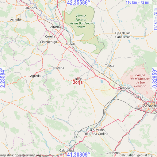
Borja GPS coordinates[2]
41° 50' 2.832" North, 1° 31' 57.756" West
| Map corner | latitude | longitude |
|---|---|---|
| Upper-left | 42.35586°, | -2.23584° |
| Center: | 41.83412°, | -1.53271° |
| Lower-right: | 41.30809°, | -0.82959° |
| Map W x H: | 116.5×116.5 km | = 72.4×72.4mi |
| max Lat: | 43.74134° ⇑30.5% North |
| Borja: | 41.83412° |
| min Lat: | ⇓69.5% South 27.64134° |
| min Long | Borja | max Long |
| -18.00367° | -1.53271° | 4.2899° |
| W 72.6%⇐ | ⇒27.4% E |
Elevation
Elevation of Borja is 458 m = 1503 ft, and this is 140 m = 459 ft below average elevation for this country.
| Max E: |
1682 m = 5518 ft | 65.1% |
| Avg. | 598 m = 1962 ft | |
| Borja | 458 m = 1503 ft | |
Min E: |
0 m = 0 ft | 34.9% |
See also: Spain elevation on elevation.city.
Geographical zone
Borja is located in North temperate zone (between Tropic of Cancer and the Arctic Circle). Distance of this Northern Tropic circle is 2045.6 km =1271.1 mi to South.| Distance of | km | miles | from Borja |
|---|---|---|---|
| North Pole | 5355.5 | 3327.8 | to North |
| Arctic Circle | 2749.7 | 1708.6 | to North |
| Tropic Cancer | 2045.6 | 1271.1 | to South |
| Equator | 4651.5 | 2890.3 | to South |


Nearby cities:
15 places around Borja: (largest is in red/bold)
• Agón
7.1 km =4.4 mi,  70°
70°
• Ainzón
2.2 km =1.4 mi,  151°
151°
• Alberite de San Juan
5.4 km =3.4 mi,  106°
106°
• Albeta
2.9 km =1.8 mi, 107°
• Ambel
8.1 km =5 mi,  237°
237°
• Bisimbre
7.8 km =4.8 mi, 71°
• Bulbuente
6 km =3.7 mi,  254°
254°
• Bureta
4.2 km =2.6 mi,  119°
119°
• Fréscano
8.8 km =5.5 mi,  51°
51°
• Fuendejalón
9.6 km =6 mi, 148°
• Magallón
6 km =3.7 mi,  91°
91°
• Maleján
1.5 km =0.9 mi, 241°
• Mallén
11.9 km =7.4 mi, 51°
• Pozuelo de Aragón
12 km =7.5 mi,  130°
130°
• Vera de Moncayo
12.9 km =8 mi,  265°
265°
Sources, notices
• [Note1] Compared only with cities in Spain existing in our database
• [Src1] Map data: © OpenStreetMap contributors (CC-BY-SA)
• [Src2] Other city data from geonames.org with taken over terms of usage.
• [Src3] Geographical zone / Annual Mean Temperature by Robert A. Rohde @ Wikipedia
