Sarrià-Sant Gervasi geodata
Sarrià-Sant Gervasi (Catalonia) is a section of populated place; located in Spain in Europe/Madrid (GMT+2) time zone. With population of 147,912 people, there are 60 cities with bigger population in this country. Compared to other cities in Spain, 57.8% of cities are located further ↓South; 94.1% of cities are located further ←West and 86% of cities have higher elevation than Sarrià-Sant Gervasi. Note1
Administrative division(s):
- Level 1: Catalonia
- Level 2: Província de Barcelona
- Level 3: Barcelona
- Level 4: Sarrià-Sant Gervasi


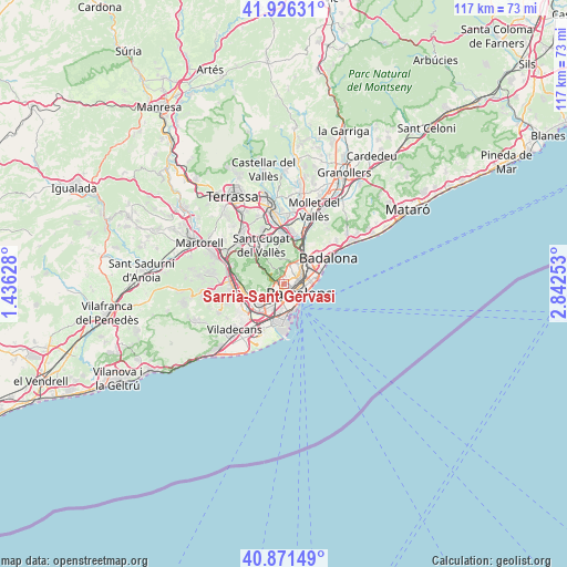
Sarrià-Sant Gervasi GPS coordinates[2]
41° 24' 3.744" North, 2° 8' 21.84" East
| Map corner | latitude | longitude |
|---|---|---|
| Upper-left | 41.92631°, | 1.43628° |
| Center: | 41.40104°, | 2.1394° |
| Lower-right: | 40.87149°, | 2.84253° |
| Map W x H: | 117.3×117.3 km | = 72.9×72.9mi |
| max Lat: | 43.74134° ⇑42.2% North |
| Sarrià-Sant Gervasi: | 41.40104° |
| min Lat: | ⇓57.8% South 27.64134° |
| min Long | Sarrià-Sant Ge | max Long |
| -18.00367° | 2.1394° | 4.2899° |
| W 94.1%⇐ | ⇒5.9% E |
Elevation
Elevation of Sarrià-Sant Gervasi is 124 m = 407 ft, and this is 474 m = 1555 ft below average elevation for this country.
| Max E: |
1682 m = 5518 ft | 86% |
| Avg. | 598 m = 1962 ft | |
| Sarrià-Sant Gervasi | 124 m = 407 ft | |
Min E: |
0 m = 0 ft | 14% |
See also: Sarrià-Sant Gervasi elevation on elevation.city.
Geographical zone
Sarrià-Sant Gervasi is located in North temperate zone (between Tropic of Cancer and the Arctic Circle). Distance of this Northern Tropic circle is 1997.4 km =1241.1 mi to South.| Distance of | km | miles | from Sarrià-Sant Gervasi |
|---|---|---|---|
| North Pole | 5403.7 | 3357.7 | to North |
| Arctic Circle | 2797.8 | 1738.5 | to North |
| Tropic Cancer | 1997.4 | 1241.1 | to South |
| Equator | 4603.4 | 2860.4 | to South |


Nearby cities:
15 places around Sarrià-Sant Gervasi: (largest is in red/bold)
• Barcelona
2.1 km =1.3 mi,  129°
129°
• Barri de les Corts
1.6 km =1 mi,  194°
194°
• Gràcia
1.4 km =0.9 mi,  84°
84°
• La Bonanova
0.8 km =0.5 mi,  312°
312°
• Las Tres Torres
0.9 km =0.6 mi,  261°
261°
• Les Corts
1.7 km =1.1 mi,  206°
206°
• Sant Gervasi - Galvany
0.5 km =0.3 mi,  142°
142°
• Sarrià
1.9 km =1.2 mi,  275°
275°
• Vallcarca
1.3 km =0.8 mi,  17°
17°
• el Camp d'en Grassot i Gràcia Nova
2.2 km =1.4 mi,  74°
74°
• el Coll
1.9 km =1.2 mi, 19°
• el Putxet i el Farró
0.8 km =0.5 mi,  29°
29°
• l'Antiga Esquerra de l'Eixample
1.8 km =1.1 mi, 134°
• la Salut
1.8 km =1.1 mi,  44°
44°
• la Vila de Gràcia
1.5 km =0.9 mi, 80°
Sources, notices
• [Note1] Compared only with cities in Spain existing in our database
• [Src1] Map data: © OpenStreetMap contributors (CC-BY-SA)
• [Src2] Other city data from geonames.org with taken over terms of usage.
• [Src3] Geographical zone / Annual Mean Temperature by Robert A. Rohde @ Wikipedia
