Gràcia geodata
Gràcia (Catalonia) is a section of populated place; located in Spain in Europe/Madrid (GMT+2) time zone. With population of 121,502 people, there are 75 cities with bigger population in this country. Compared to other cities in Spain, 57.8% of cities are located further ↓South; 94.4% of cities are located further ←West and 89.3% of cities have higher elevation than Gràcia. Note1
Administrative division(s):
- Level 1: Catalonia
- Level 2: Província de Barcelona
- Level 3: Barcelona
- Level 4: Gràcia


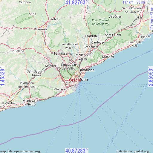
Gràcia GPS coordinates[2]
41° 24' 8.532" North, 2° 9' 23.076" East
| Map corner | latitude | longitude |
|---|---|---|
| Upper-left | 41.92763°, | 1.45328° |
| Center: | 41.40237°, | 2.15641° |
| Lower-right: | 40.87283°, | 2.85953° |
| Map W x H: | 117.3×117.3 km | = 72.9×72.9mi |
| max Lat: | 43.74134° ⇑42.2% North |
| Gràcia: | 41.40237° |
| min Lat: | ⇓57.8% South 27.64134° |
| min Long | Gràcia | max Long |
| -18.00367° | 2.15641° | 4.2899° |
| W 94.4%⇐ | ⇒5.6% E |
Elevation
Elevation of Gràcia is 76 m = 249 ft, and this is 522 m = 1713 ft below average elevation for this country.
| Max E: |
1682 m = 5518 ft | 89.3% |
| Avg. | 598 m = 1962 ft | |
| Gràcia | 76 m = 249 ft | |
Min E: |
0 m = 0 ft | 10.7% |
See also: Gràcia elevation on elevation.city.
Geographical zone
Gràcia is located in North temperate zone (between Tropic of Cancer and the Arctic Circle). Distance of this Northern Tropic circle is 1997.6 km =1241.3 mi to South.| Distance of | km | miles | from Gràcia |
|---|---|---|---|
| North Pole | 5403.5 | 3357.6 | to North |
| Arctic Circle | 2797.7 | 1738.4 | to North |
| Tropic Cancer | 1997.6 | 1241.3 | to South |
| Equator | 4603.5 | 2860.5 | to South |


Nearby cities:
15 places around Gràcia: (largest is in red/bold)
• Barcelona
1.5 km =0.9 mi,  171°
171°
• Can Baró
1.7 km =1.1 mi,  17°
17°
• Dreta de l'Eixample
1.1 km =0.7 mi,  128°
128°
• Eixample
1.6 km =1 mi,  163°
163°
• El Carmel
1.7 km =1.1 mi,  7°
7°
• Sagrada Família
1.4 km =0.9 mi,  82°
82°
• Sant Gervasi - Galvany
1.2 km =0.7 mi,  244°
244°
• Sarrià-Sant Gervasi
1.4 km =0.9 mi,  264°
264°
• Vallcarca
1.5 km =0.9 mi,  316°
316°
• el Baix Guinardó
1.4 km =0.9 mi,  42°
42°
• el Camp d'en Grassot i Gràcia Nova
0.8 km =0.5 mi,  58°
58°
• el Putxet i el Farró
1.2 km =0.7 mi,  295°
295°
• l'Antiga Esquerra de l'Eixample
1.4 km =0.9 mi,  184°
184°
• la Salut
1.1 km =0.7 mi,  351°
351°
• la Vila de Gràcia
0.1 km =0.1 mi, 23°
Sources, notices
• [Note1] Compared only with cities in Spain existing in our database
• [Src1] Map data: © OpenStreetMap contributors (CC-BY-SA)
• [Src2] Other city data from geonames.org with taken over terms of usage.
• [Src3] Geographical zone / Annual Mean Temperature by Robert A. Rohde @ Wikipedia
