Basauri geodata
Basauri (Basque Country) is a seat of a third-order administrative division; located in Spain in Europe/Madrid (GMT+2) time zone. With population of 42,657 people, there are 207 cities with bigger population in this country. Compared to other cities in Spain, 96.8% of cities are located further ↓South; 56.2% of cities are located further ←West and 90.5% of cities have higher elevation than Basauri. Note1


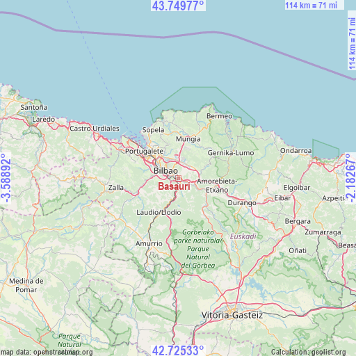
Basauri GPS coordinates[2]
43° 14' 22.92" North, 2° 53' 8.88" West
| Map corner | latitude | longitude |
|---|---|---|
| Upper-left | 43.74977°, | -3.58892° |
| Center: | 43.2397°, | -2.8858° |
| Lower-right: | 42.72533°, | -2.18267° |
| Map W x H: | 113.9×113.9 km | = 70.8×70.8mi |
| max Lat: | 43.74134° ⇑3.2% North |
| Basauri: | 43.2397° |
| min Lat: | ⇓96.8% South 27.64134° |
| min Long | Basauri | max Long |
| -18.00367° | -2.8858° | 4.2899° |
| W 56.2%⇐ | ⇒43.8% E |
Elevation
Elevation of Basauri is 57 m = 187 ft, and this is 541 m = 1775 ft below average elevation for this country.
| Max E: |
1682 m = 5518 ft | 90.5% |
| Avg. | 598 m = 1962 ft | |
| Basauri | 57 m = 187 ft | |
Min E: |
0 m = 0 ft | 9.5% |
See also: Basauri elevation on elevation.city.
Geographical zone
Basauri is located in North temperate zone (between Tropic of Cancer and the Arctic Circle). Distance of this Northern Tropic circle is 2201.9 km =1368.2 mi to South.| Distance of | km | miles | from Basauri |
|---|---|---|---|
| North Pole | 5199.3 | 3230.7 | to North |
| Arctic Circle | 2593.4 | 1611.5 | to North |
| Tropic Cancer | 2201.9 | 1368.2 | to South |
| Equator | 4807.8 | 2987.4 | to South |


Nearby cities:
15 places around Basauri: (largest is in red/bold)
• Alonsotegi
8.3 km =5.2 mi,  273°
273°
• Arrigorriaga
3.3 km =2.1 mi,  179°
179°
• Barakaldo
10.4 km =6.5 mi,  307°
307°
• Bilbao
4.1 km =2.5 mi, 308°
• Derio
7.3 km =4.5 mi,  2°
2°
• Elexalde
10.7 km =6.6 mi,  201°
201°
• Erandio
10.1 km =6.3 mi,  315°
315°
• Erandiogoikoa
9.4 km =5.8 mi, 323°
• Galdakao
3.6 km =2.2 mi,  106°
106°
• Laudio / Llodio
12.4 km =7.7 mi,  209°
209°
• Santutxu
2.9 km =1.8 mi,  301°
301°
• Sestao
12.5 km =7.8 mi, 308°
• Sondika
7.4 km =4.6 mi,  335°
335°
• Zamudio
5.3 km =3.3 mi,  13°
13°
• Zaratamo
3 km =1.9 mi,  148°
148°
Sources, notices
• [Note1] Compared only with cities in Spain existing in our database
• [Src1] Map data: © OpenStreetMap contributors (CC-BY-SA)
• [Src2] Other city data from geonames.org with taken over terms of usage.
• [Src3] Geographical zone / Annual Mean Temperature by Robert A. Rohde @ Wikipedia
