Elexalde geodata
Elexalde (Basque Country) is a seat of a third-order administrative division; located in Spain in Europe/Madrid (GMT+2) time zone. With population of 96 people, there are 5985 cities with bigger population in this country. Compared to other cities in Spain, 95.8% of cities are located further ↓South; 55.5% of cities are located further ←West and 82.1% of cities have higher elevation than Elexalde. Note1


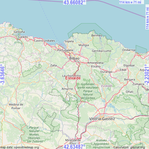
Elexalde GPS coordinates[2]
43° 9' 0" North, 2° 55' 59.988" West
| Map corner | latitude | longitude |
|---|---|---|
| Upper-left | 43.66082°, | -3.63646° |
| Center: | 43.15°, | -2.93333° |
| Lower-right: | 42.63487°, | -2.23021° |
| Map W x H: | 114.1×114.1 km | = 70.9×70.9mi |
| max Lat: | 43.74134° ⇑4.2% North |
| Elexalde: | 43.15° |
| min Lat: | ⇓95.8% South 27.64134° |
| min Long | Elexalde | max Long |
| -18.00367° | -2.93333° | 4.2899° |
| W 55.5%⇐ | ⇒44.5% E |
Elevation
Elevation of Elexalde is 183 m = 600 ft, and this is 415 m = 1362 ft below average elevation for this country.
| Max E: |
1682 m = 5518 ft | 82.1% |
| Avg. | 598 m = 1962 ft | |
| Elexalde | 183 m = 600 ft | |
Min E: |
0 m = 0 ft | 17.9% |
See also: Spain elevation on elevation.city.
Geographical zone
Elexalde is located in North temperate zone (between Tropic of Cancer and the Arctic Circle). Distance of this Northern Tropic circle is 2191.9 km =1362 mi to South.| Distance of | km | miles | from Elexalde |
|---|---|---|---|
| North Pole | 5209.2 | 3236.8 | to North |
| Arctic Circle | 2603.3 | 1617.6 | to North |
| Tropic Cancer | 2191.9 | 1362 | to South |
| Equator | 4797.8 | 2981.2 | to South |


Nearby cities:
15 places around Elexalde: (largest is in red/bold)
• Alonsotegi
11.4 km =7.1 mi,  337°
337°
• Amurrio
12.4 km =7.7 mi,  205°
205°
• Areatza
14 km =8.7 mi,  105°
105°
• Arrigorriaga
7.7 km =4.8 mi,  30°
30°
• Basauri
10.7 km =6.6 mi,  21°
21°
• Bilbao
12.5 km =7.8 mi,  2°
2°
• Galdakao
11.6 km =7.2 mi,  39°
39°
• Gordexola
12 km =7.5 mi,  285°
285°
• Güeñes
14.8 km =9.2 mi,  297°
297°
• Herriko Plaza
12.3 km =7.6 mi,  98°
98°
• Laudio / Llodio
2.4 km =1.5 mi,  252°
252°
• Lezama
13.9 km =8.6 mi,  193°
193°
• Santutxu
11.6 km =7.2 mi,  6°
6°
• Zaratamo
9.2 km =5.7 mi, 36°
• Zeanuri
15.9 km =9.9 mi, 110°
Sources, notices
• [Note1] Compared only with cities in Spain existing in our database
• [Src1] Map data: © OpenStreetMap contributors (CC-BY-SA)
• [Src2] Other city data from geonames.org with taken over terms of usage.
• [Src3] Geographical zone / Annual Mean Temperature by Robert A. Rohde @ Wikipedia
