Porta geodata
Porta (Catalonia) is a section of populated place; located in Spain in Europe/Madrid (GMT+2) time zone. With population of 24,604 people, there are 380 cities with bigger population in this country. Compared to other cities in Spain, 59.1% of cities are located further ↓South; 94.9% of cities are located further ←West and 90.8% of cities have higher elevation than Porta. Note1
Administrative division(s):
- Level 1: Catalonia
- Level 2: Província de Barcelona
- Level 3: Barcelona
- Level 4: Nou Barris


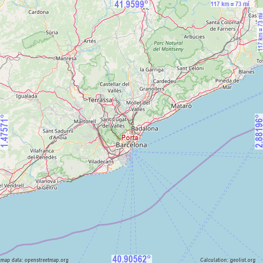
Porta GPS coordinates[2]
41° 26' 5.64" North, 2° 10' 43.788" East
| Map corner | latitude | longitude |
|---|---|---|
| Upper-left | 41.9599°, | 1.47571° |
| Center: | 41.4349°, | 2.17883° |
| Lower-right: | 40.90562°, | 2.88196° |
| Map W x H: | 117.2×117.2 km | = 72.8×72.8mi |
| max Lat: | 43.74134° ⇑40.9% North |
| Porta: | 41.4349° |
| min Lat: | ⇓59.1% South 27.64134° |
| min Long | Porta | max Long |
| -18.00367° | 2.17883° | 4.2899° |
| W 94.9%⇐ | ⇒5.1% E |
Elevation
Elevation of Porta is 54 m = 177 ft, and this is 544 m = 1785 ft below average elevation for this country.
| Max E: |
1682 m = 5518 ft | 90.8% |
| Avg. | 598 m = 1962 ft | |
| Porta | 54 m = 177 ft | |
Min E: |
0 m = 0 ft | 9.2% |
See also: Spain elevation on elevation.city.
Geographical zone
Porta is located in North temperate zone (between Tropic of Cancer and the Arctic Circle). Distance of this Northern Tropic circle is 2001.2 km =1243.5 mi to South.| Distance of | km | miles | from Porta |
|---|---|---|---|
| North Pole | 5399.9 | 3355.3 | to North |
| Arctic Circle | 2794 | 1736.1 | to North |
| Tropic Cancer | 2001.2 | 1243.5 | to South |
| Equator | 4607.1 | 2862.7 | to South |


Nearby cities:
15 places around Porta: (largest is in red/bold)
• Barri de Sant Andreu
1 km =0.6 mi,  76°
76°
• Can Peguera
1 km =0.6 mi,  269°
269°
• Canyelles
1.7 km =1.1 mi,  311°
311°
• La Sagrera
1.5 km =0.9 mi,  156°
156°
• Nou Barris
0.8 km =0.5 mi,  350°
350°
• Sant Andreu
0.9 km =0.6 mi,  86°
86°
• Verdun
0.9 km =0.6 mi,  343°
343°
• Vilapicina i la Torre Llobeta
0.8 km =0.5 mi,  209°
209°
• el Congrés i els Indians
1.2 km =0.7 mi,  171°
171°
• el Turó de la Peira
0.9 km =0.6 mi,  250°
250°
• la Font d'en Fargues
1.6 km =1 mi,  224°
224°
• la Guineueta
0.9 km =0.6 mi,  297°
297°
• la Prosperitat
0.9 km =0.6 mi,  16°
16°
• la Trinitat Nova
1.8 km =1.1 mi, 16°
• les Roquetes
1.5 km =0.9 mi, 348°
Sources, notices
• [Note1] Compared only with cities in Spain existing in our database
• [Src1] Map data: © OpenStreetMap contributors (CC-BY-SA)
• [Src2] Other city data from geonames.org with taken over terms of usage.
• [Src3] Geographical zone / Annual Mean Temperature by Robert A. Rohde @ Wikipedia
