Vehmersalmi geodata
Vehmersalmi (Northern Savonia) is a populated place; located in Finland in Europe/Helsinki (GMT+3) time zone. With population of 1,889 people, there are 366 cities with bigger population in this country. Compared to other cities in Finland, 66.2% of cities are located further ↓South; 88.2% of cities are located further ←West and 62% of cities have lower elevation than Vehmersalmi. Note1


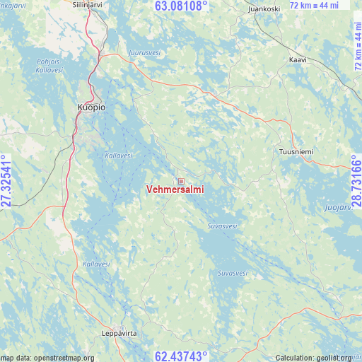
Vehmersalmi GPS coordinates[2]
62° 45' 39.636" North, 28° 1' 42.708" East
| Map corner | latitude | longitude |
|---|---|---|
| Upper-left | 63.08108°, | 27.32541° |
| Center: | 62.76101°, | 28.02853° |
| Lower-right: | 62.43743°, | 28.73166° |
| Map W x H: | 71.6×71.6 km | = 44.5×44.5mi |
| max Lat: | 69.90864° ⇑33.8% North |
| Vehmersalmi: | 62.76101° |
| min Lat: | ⇓66.2% South 59.83333° |
| min Long | Vehmersalmi | max Long |
| 21.2° | 28.02853° | 30.93276° |
| W 88.2%⇐ | ⇒11.8% E |
Elevation
Elevation of Vehmersalmi is 97 m = 318 ft, and this is 19.9 m = 65 ft above average elevation for this country.
| Max E: |
299 m = 981 ft | 38% |
| Vehmersalmi | 97 m 318 ft | |
| Avg. | 77.1 m = 253 ft | |
Min E: |
1 m = 3 ft | 62% |
See also: Finland elevation on elevation.city.
Geographical zone
Vehmersalmi is located in North temperate zone (between Tropic of Cancer and the Arctic Circle). Distance of this North polar circle is 422.8 km =262.7 mi to North.| Distance of | km | miles | from Vehmersalmi |
|---|---|---|---|
| North Pole | 3028.7 | 1881.9 | to North |
| Arctic Circle | 422.8 | 262.7 | to North |
| Tropic Cancer | 4372.5 | 2716.9 | to South |
| Equator | 6978.4 | 4336.2 | to South |


Nearby cities:
15 places around Vehmersalmi: (largest is in red/bold)
• Heinävesi
46.7 km =29 mi,  141°
141°
• Juankoski
37.7 km =23.4 mi,  25°
25°
• Jäppilä
52.3 km =32.5 mi,  215°
215°
• Kaavi
34.4 km =21.4 mi,  44°
44°
• Kangaslampi
53 km =32.9 mi,  167°
167°
• Karttula
55.8 km =34.7 mi,  285°
285°
• Kuopio
23.1 km =14.4 mi,  309°
309°
• Leppävirta
32.6 km =20.3 mi,  202°
202°
• Maaninka
57.3 km =35.6 mi,  319°
319°
• Nilsiä
49.7 km =30.9 mi,  3°
3°
• Outokumpu
50.4 km =31.3 mi,  94°
94°
• Siilinjärvi
40.2 km =25 mi,  332°
332°
• Suonenjoki
48.4 km =30.1 mi,  250°
250°
• Tuusniemi
24.8 km =15.4 mi,  75°
75°
• Varkaus
50.2 km =31.2 mi,  189°
189°
Sources, notices
• [Note1] Compared only with cities in Finland existing in our database
• [Src1] Map data: © OpenStreetMap contributors (CC-BY-SA)
• [Src2] Other city data from geonames.org with taken over terms of usage.
• [Src3] Geographical zone / Annual Mean Temperature by Robert A. Rohde @ Wikipedia
