Kangaslampi geodata
Kangaslampi (Northern Savonia) is a populated place; located in Finland in Europe/Helsinki (GMT+3) time zone. With population of 1,596 people, there are 384 cities with bigger population in this country. Compared to other cities in Finland, 57.9% of cities are located further ↓South; 90.2% of cities are located further ←West and 57.5% of cities have lower elevation than Kangaslampi. Note1


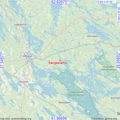
Kangaslampi GPS coordinates[2]
62° 17' 44.268" North, 28° 15' 10.404" East
| Map corner | latitude | longitude |
|---|---|---|
| Upper-left | 62.62075°, | 27.54977° |
| Center: | 62.29563°, | 28.25289° |
| Lower-right: | 61.96696°, | 28.95602° |
| Map W x H: | 72.7×72.7 km | = 45.2×45.2mi |
| max Lat: | 69.90864° ⇑42.1% North |
| Kangaslampi: | 62.29563° |
| min Lat: | ⇓57.9% South 59.83333° |
| min Long | Kangaslampi | max Long |
| 21.2° | 28.25289° | 30.93276° |
| W 90.2%⇐ | ⇒9.8% E |
Elevation
Elevation of Kangaslampi is 91 m = 299 ft, and this is 13.9 m = 46 ft above average elevation for this country.
| Max E: |
299 m = 981 ft | 42.5% |
| Kangaslampi | 91 m 299 ft | |
| Avg. | 77.1 m = 253 ft | |
Min E: |
1 m = 3 ft | 57.5% |
See also: Finland elevation on elevation.city.
Geographical zone
Kangaslampi is located in North temperate zone (between Tropic of Cancer and the Arctic Circle). Distance of this North polar circle is 474.5 km =294.8 mi to North.| Distance of | km | miles | from Kangaslampi |
|---|---|---|---|
| North Pole | 3080.4 | 1914.1 | to North |
| Arctic Circle | 474.5 | 294.8 | to North |
| Tropic Cancer | 4320.7 | 2684.8 | to South |
| Equator | 6926.6 | 4304 | to South |


Nearby cities:
15 places around Kangaslampi: (largest is in red/bold)
• Enonkoski
42.5 km =26.4 mi,  123°
123°
• Heinävesi
23.6 km =14.7 mi,  49°
49°
• Joroinen
25.4 km =15.8 mi,  239°
239°
• Juva
48.7 km =30.3 mi,  205°
205°
• Jäppilä
43.3 km =26.9 mi,  282°
282°
• Leppävirta
32.5 km =20.2 mi,  311°
311°
• Pieksämäki
57.9 km =36 mi,  270°
270°
• Rantasalmi
25.6 km =15.9 mi,  174°
174°
• Savonlinna
57.5 km =35.7 mi,  145°
145°
• Savonranta
50.6 km =31.4 mi,  104°
104°
• Sulkava
56.9 km =35.4 mi, 173°
• Tuusniemi
59.3 km =36.8 mi,  12°
12°
• Varkaus
19.8 km =12.3 mi, 276°
• Vehmersalmi
53 km =32.9 mi,  347°
347°
• Virtasalmi
45 km =28 mi,  245°
245°
Sources, notices
• [Note1] Compared only with cities in Finland existing in our database
• [Src1] Map data: © OpenStreetMap contributors (CC-BY-SA)
• [Src2] Other city data from geonames.org with taken over terms of usage.
• [Src3] Geographical zone / Annual Mean Temperature by Robert A. Rohde @ Wikipedia
