Keitele geodata
Keitele (Northern Savonia) is a seat of a third-order administrative division; located in Finland in Europe/Helsinki (GMT+3) time zone. With population of 2,832 people, there are 310 cities with bigger population in this country. Compared to other cities in Finland, 75% of cities are located further ↓South; 74.1% of cities are located further ←West and 65% of cities have lower elevation than Keitele. Note1


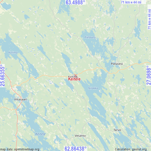
Keitele GPS coordinates[2]
63° 10' 59.988" North, 26° 22' 0.012" East
| Map corner | latitude | longitude |
|---|---|---|
| Upper-left | 63.4988°, | 25.66355° |
| Center: | 63.18333°, | 26.36667° |
| Lower-right: | 62.86438°, | 27.0698° |
| Map W x H: | 70.5×70.5 km | = 43.8×43.8mi |
| max Lat: | 69.90864° ⇑25% North |
| Keitele: | 63.18333° |
| min Lat: | ⇓75% South 59.83333° |
| min Long | Keitele | max Long |
| 21.2° | 26.36667° | 30.93276° |
| W 74.1%⇐ | ⇒25.9% E |
Elevation
Elevation of Keitele is 101 m = 331 ft, and this is 23.9 m = 78 ft above average elevation for this country.
| Max E: |
299 m = 981 ft | 35% |
| Keitele | 101 m 331 ft | |
| Avg. | 77.1 m = 253 ft | |
Min E: |
1 m = 3 ft | 65% |
See also: Finland elevation on elevation.city.
Geographical zone
Keitele is located in North temperate zone (between Tropic of Cancer and the Arctic Circle). Distance of this North polar circle is 375.8 km =233.5 mi to North.| Distance of | km | miles | from Keitele |
|---|---|---|---|
| North Pole | 2981.7 | 1852.7 | to North |
| Arctic Circle | 375.8 | 233.5 | to North |
| Tropic Cancer | 4419.4 | 2746.1 | to South |
| Equator | 7025.3 | 4365.3 | to South |


Nearby cities:
15 places around Keitele: (largest is in red/bold)
• Iisalmi
58.6 km =36.4 mi,  44°
44°
• Kannonkoski
61.2 km =38 mi,  246°
246°
• Karttula
44.1 km =27.4 mi,  136°
136°
• Kiuruvesi
53.4 km =33.2 mi,  13°
13°
• Konnevesi
63.1 km =39.2 mi,  182°
182°
• Lapinlahti
55.5 km =34.5 mi,  68°
68°
• Maaninka
46.9 km =29.1 mi,  93°
93°
• Pielavesi
20 km =12.4 mi, 73°
• Pihtipudas
45.8 km =28.5 mi,  299°
299°
• Pyhäjärvi
58.5 km =36.4 mi,  336°
336°
• Pyhäsalmi
58.8 km =36.5 mi, 341°
• Sumiainen
60.7 km =37.7 mi,  195°
195°
• Tervo
32.3 km =20.1 mi, 143°
• Vesanto
27.9 km =17.3 mi,  174°
174°
• Viitasaari
28.3 km =17.6 mi,  242°
242°
Sources, notices
• [Note1] Compared only with cities in Finland existing in our database
• [Src1] Map data: © OpenStreetMap contributors (CC-BY-SA)
• [Src2] Other city data from geonames.org with taken over terms of usage.
• [Src3] Geographical zone / Annual Mean Temperature by Robert A. Rohde @ Wikipedia
