Konnevesi geodata
Konnevesi (Central Finland) is a seat of a third-order administrative division; located in Finland in Europe/Helsinki (GMT+3) time zone. With population of 3,132 people, there are 290 cities with bigger population in this country. Compared to other cities in Finland, 63.5% of cities are located further ↓South; 73.5% of cities are located further ←West and 80.1% of cities have lower elevation than Konnevesi. Note1


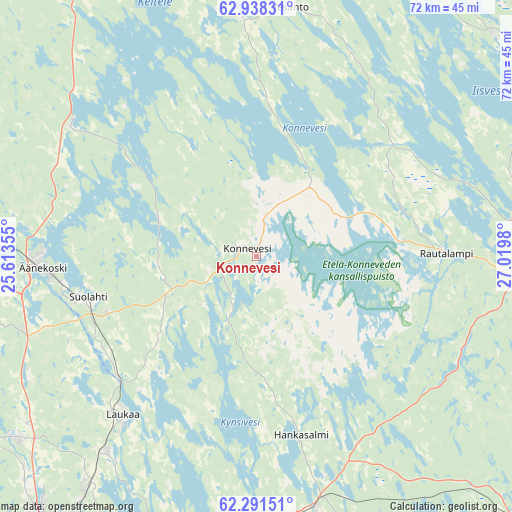
Konnevesi GPS coordinates[2]
62° 37' 0.012" North, 26° 19' 0.012" East
| Map corner | latitude | longitude |
|---|---|---|
| Upper-left | 62.93831°, | 25.61355° |
| Center: | 62.61667°, | 26.31667° |
| Lower-right: | 62.29151°, | 27.0198° |
| Map W x H: | 71.9×71.9 km | = 44.7×44.7mi |
| max Lat: | 69.90864° ⇑36.5% North |
| Konnevesi: | 62.61667° |
| min Lat: | ⇓63.5% South 59.83333° |
| min Long | Konnevesi | max Long |
| 21.2° | 26.31667° | 30.93276° |
| W 73.5%⇐ | ⇒26.5% E |
Elevation
Elevation of Konnevesi is 117 m = 384 ft, and this is 39.9 m = 131 ft above average elevation for this country.
| Max E: |
299 m = 981 ft | 19.9% |
| Konnevesi | 117 m 384 ft | |
| Avg. | 77.1 m = 253 ft | |
Min E: |
1 m = 3 ft | 80.1% |
See also: Finland elevation on elevation.city.
Geographical zone
Konnevesi is located in North temperate zone (between Tropic of Cancer and the Arctic Circle). Distance of this North polar circle is 438.9 km =272.7 mi to North.| Distance of | km | miles | from Konnevesi |
|---|---|---|---|
| North Pole | 3044.7 | 1891.9 | to North |
| Arctic Circle | 438.9 | 272.7 | to North |
| Tropic Cancer | 4356.4 | 2706.9 | to South |
| Equator | 6962.3 | 4326.2 | to South |


Nearby cities:
15 places around Konnevesi: (largest is in red/bold)
• Hankasalmi
26.6 km =16.5 mi,  167°
167°
• Jyväskylä
51.8 km =32.2 mi,  216°
216°
• Karttula
45.5 km =28.3 mi,  46°
46°
• Laukaa
29.3 km =18.2 mi, 219°
• Pieksämäki
54.8 km =34.1 mi,  129°
129°
• Rautalampi
26.5 km =16.5 mi,  85°
85°
• Saarijärvi
55.1 km =34.2 mi,  280°
280°
• Sumiainen
14.5 km =9 mi,  288°
288°
• Suolahti
24.4 km =15.2 mi,  256°
256°
• Suonenjoki
41.8 km =26 mi, 90°
• Tervo
43.1 km =26.8 mi,  30°
30°
• Uurainen
46.3 km =28.8 mi,  253°
253°
• Vesanto
35.6 km =22.1 mi,  8°
8°
• Viitasaari
55 km =34.2 mi,  335°
335°
• Äänekoski
29.9 km =18.6 mi,  266°
266°
Sources, notices
• [Note1] Compared only with cities in Finland existing in our database
• [Src1] Map data: © OpenStreetMap contributors (CC-BY-SA)
• [Src2] Other city data from geonames.org with taken over terms of usage.
• [Src3] Geographical zone / Annual Mean Temperature by Robert A. Rohde @ Wikipedia
