Ii geodata
Ii (Northern Ostrobothnia) is a seat of a third-order administrative division; located in Finland in Europe/Helsinki (GMT+3) time zone. With population of 6,546 people, there are 164 cities with bigger population in this country. Compared to other cities in Finland, 93.8% of cities are located further ↓South; 62.2% of cities are located further ←West and 90.6% of cities have higher elevation than Ii. Note1


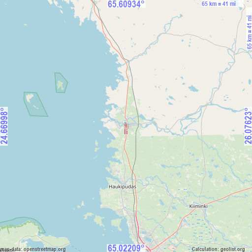
Ii GPS coordinates[2]
65° 19' 2.46" North, 25° 22' 23.16" East
| Map corner | latitude | longitude |
|---|---|---|
| Upper-left | 65.60934°, | 24.66998° |
| Center: | 65.31735°, | 25.3731° |
| Lower-right: | 65.02209°, | 26.07623° |
| Map W x H: | 65.3×65.3 km | = 40.6×40.6mi |
| max Lat: | 69.90864° ⇑6.2% North |
| Ii: | 65.31735° |
| min Lat: | ⇓93.8% South 59.83333° |
| min Long | Ii | max Long |
| 21.2° | 25.3731° | 30.93276° |
| W 62.2%⇐ | ⇒37.8% E |
Elevation
Elevation of Ii is 12 m = 39 ft, and this is 65.1 m = 214 ft below average elevation for this country.
| Max E: |
299 m = 981 ft | 90.6% |
| Avg. | 77.1 m = 253 ft | |
| Ii | 12 m = 39 ft | |
Min E: |
1 m = 3 ft | 9.4% |
See also: Finland elevation on elevation.city.
Geographical zone
Ii is located in North temperate zone (between Tropic of Cancer and the Arctic Circle). Distance of this North polar circle is 138.6 km =86.1 mi to North.| Distance of | km | miles | from Ii |
|---|---|---|---|
| North Pole | 2744.5 | 1705.4 | to North |
| Arctic Circle | 138.6 | 86.1 | to North |
| Tropic Cancer | 4656.7 | 2893.5 | to South |
| Equator | 7262.6 | 4512.8 | to South |


Nearby cities:
15 places around Ii: (largest is in red/bold)
• Hailuoto
46.1 km =28.6 mi,  221°
221°
• Haukipudas
15.7 km =9.8 mi,  183°
183°
• Kemi
59.7 km =37.1 mi,  321°
321°
• Kempele
45.4 km =28.2 mi,  172°
172°
• Kiiminki
28.6 km =17.8 mi,  136°
136°
• Kuivaniemi
30.3 km =18.8 mi,  343°
343°
• Liminka
56.5 km =35.1 mi, 177°
• Lumijoki
54.1 km =33.6 mi,  189°
189°
• Oulu
34.2 km =21.3 mi, 172°
• Oulunsalo
42.6 km =26.5 mi, 177°
• Siikajoki
62.9 km =39.1 mi,  207°
207°
• Simo
41.6 km =25.8 mi, 339°
• Tyrnävä
62.8 km =39 mi, 167°
• Yli-Ii
22.7 km =14.1 mi,  74°
74°
• Ylikiiminki
48.5 km =30.1 mi,  122°
122°
Sources, notices
• [Note1] Compared only with cities in Finland existing in our database
• [Src1] Map data: © OpenStreetMap contributors (CC-BY-SA)
• [Src2] Other city data from geonames.org with taken over terms of usage.
• [Src3] Geographical zone / Annual Mean Temperature by Robert A. Rohde @ Wikipedia
