Hailuoto geodata
Hailuoto (Northern Ostrobothnia) is a seat of a third-order administrative division; located in Finland in Europe/Helsinki (GMT+3) time zone. With population of 955 people, there are 427 cities with bigger population in this country. Compared to other cities in Finland, 92.7% of cities are located further ↓South; 50.9% of cities are located further →East and 92.7% of cities have higher elevation than Hailuoto. Note1


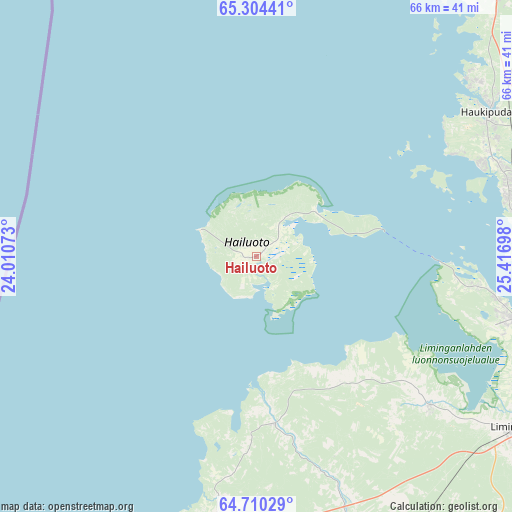
Hailuoto GPS coordinates[2]
65° 0' 32.4" North, 24° 42' 49.86" East
| Map corner | latitude | longitude |
|---|---|---|
| Upper-left | 65.30441°, | 24.01073° |
| Center: | 65.009°, | 24.71385° |
| Lower-right: | 64.71029°, | 25.41698° |
| Map W x H: | 66.1×66.1 km | = 41.1×41.1mi |
| max Lat: | 69.90864° ⇑7.3% North |
| Hailuoto: | 65.009° |
| min Lat: | ⇓92.7% South 59.83333° |
| min Long | Hailuoto | max Long |
| 21.2° | 24.71385° | 30.93276° |
| W 49.1%⇐ | ⇒50.9% E |
Elevation
Elevation of Hailuoto is 10 m = 33 ft, and this is 67.1 m = 220 ft below average elevation for this country.
| Max E: |
299 m = 981 ft | 92.7% |
| Avg. | 77.1 m = 253 ft | |
| Hailuoto | 10 m = 33 ft | |
Min E: |
1 m = 3 ft | 7.3% |
See also: Finland elevation on elevation.city.
Geographical zone
Hailuoto is located in North temperate zone (between Tropic of Cancer and the Arctic Circle). Distance of this North polar circle is 172.9 km =107.4 mi to North.| Distance of | km | miles | from Hailuoto |
|---|---|---|---|
| North Pole | 2778.7 | 1726.6 | to North |
| Arctic Circle | 172.9 | 107.4 | to North |
| Tropic Cancer | 4622.4 | 2872.2 | to South |
| Equator | 7228.3 | 4491.5 | to South |


Nearby cities:
15 places around Hailuoto: (largest is in red/bold)
• Haukipudas
35.2 km =21.9 mi,  58°
58°
• Ii
46.1 km =28.6 mi,  41°
41°
• Kempele
38.7 km =24 mi,  106°
106°
• Kiiminki
52.6 km =32.7 mi,  74°
74°
• Liminka
39.8 km =24.7 mi,  123°
123°
• Lumijoki
29.3 km =18.2 mi,  130°
130°
• Muhos
64.3 km =40 mi, 110°
• Oulu
35.4 km =22 mi,  89°
89°
• Oulunsalo
33.8 km =21 mi,  104°
104°
• Pyhäjoki
64.5 km =40.1 mi,  200°
200°
• Raahe
37.8 km =23.5 mi, 196°
• Ruukki
42.2 km =26.2 mi,  154°
154°
• Siikajoki
21.7 km =13.5 mi,  174°
174°
• Tyrnävä
52 km =32.3 mi, 121°
• Vihanti
59.8 km =37.2 mi, 167°
Sources, notices
• [Note1] Compared only with cities in Finland existing in our database
• [Src1] Map data: © OpenStreetMap contributors (CC-BY-SA)
• [Src2] Other city data from geonames.org with taken over terms of usage.
• [Src3] Geographical zone / Annual Mean Temperature by Robert A. Rohde @ Wikipedia
