Hoyvík geodata
Hoyvík (Streymoy) is a populated place; located in Faroe Islands in Atlantic/Faroe (GMT+1) time zone. With population of 2,777 people, there are 2 cities with bigger population in this country. Compared to other cities in Faroe Islands, 60% of cities are located further ↑North; 50% of cities are located further ←West and 50% of cities have lower elevation than Hoyvík. Note1


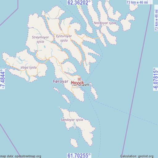
Hoyvík GPS coordinates[2]
62° 2' 2.652" North, 6° 46' 52.572" West
| Map corner | latitude | longitude |
|---|---|---|
| Upper-left | 62.36202°, | -7.4844° |
| Center: | 62.03407°, | -6.78127° |
| Lower-right: | 61.70255°, | -6.07815° |
| Map W x H: | 73.3×73.3 km | = 45.5×45.5mi |
| max Lat: | 62.35999° ⇑60% North |
| Hoyvík: | 62.03407° |
| min Lat: | ⇓40% South 61.47324° |
| min Long | Hoyvík | max Long |
| -7.30749° | -6.78127° | -6.32379° |
| W 50%⇐ | ⇒50% E |
Elevation
Elevation of Hoyvík is 76 m = 249 ft, and this is 12.4 m = 41 ft below average elevation for this country.
| Max E: |
358 m = 1175 ft | 50% |
| Avg. | 88.4 m = 290 ft | |
| Hoyvík | 76 m = 249 ft | |
Min E: |
1 m = 3 ft | 50% |
See also: Faroe Islands elevation on elevation.city.
Geographical zone
Hoyvík is located in North temperate zone (between Tropic of Cancer and the Arctic Circle). Distance of this North polar circle is 503.6 km =312.9 mi to North.| Distance of | km | miles | from Hoyvík |
|---|---|---|---|
| North Pole | 3109.5 | 1932.2 | to North |
| Arctic Circle | 503.6 | 312.9 | to North |
| Tropic Cancer | 4291.6 | 2666.7 | to South |
| Equator | 6897.5 | 4285.9 | to South |


Nearby cities:
15 places around Hoyvík: (largest is in red/bold)
• Argir
4.3 km =2.7 mi,  173°
173°
• Eystur
19.5 km =12.1 mi,  4°
4°
• Kollafjørður
10.9 km =6.8 mi,  322°
322°
• Leirvík
20.1 km =12.5 mi,  13°
13°
• Miðvágur
21.6 km =13.4 mi,  275°
275°
• Norðragøta
18.6 km =11.6 mi, 6°
• Runavík
8.9 km =5.5 mi,  20°
20°
• Saltangará
9.7 km =6 mi, 19°
• Sandavágur
19.3 km =12 mi, 276°
• Sandur
21.3 km =13.2 mi,  183°
183°
• Skopun
15.5 km =9.6 mi,  199°
199°
• Skálavík
23.4 km =14.5 mi,  164°
164°
• Strendur
8.2 km =5.1 mi, 8°
• Tórshavn
2.8 km =1.7 mi, 169°
• Ytri Skáli
13.8 km =8.6 mi,  359°
359°
Sources, notices
• [Note1] Compared only with cities in Faroe Islands existing in our database
• [Src1] Map data: © OpenStreetMap contributors (CC-BY-SA)
• [Src2] Other city data from geonames.org with taken over terms of usage.
• [Src3] Geographical zone / Annual Mean Temperature by Robert A. Rohde @ Wikipedia
