Zimming geodata
Zimming (Grand Est) is a populated place; located in France in Europe/Paris (GMT+2) time zone. With population of 649 people, there are 12531 cities with bigger population in this country. Compared to other cities in France, 82.7% of cities are located further ↓South; 92.3% of cities are located further ←West and 87.3% of cities have lower elevation than Zimming. Note1
Administrative division(s):
- Level 1: Grand Est
- Level 2: Moselle
- Level 3: Arrondissement de Forbach-Boulay-Moselle
- Level 4: Zimming


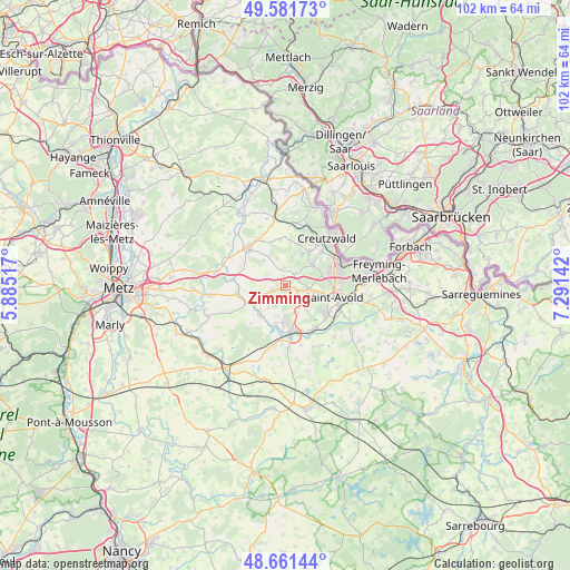
Zimming GPS coordinates[2]
49° 7' 25.392" North, 6° 35' 17.844" East
| Map corner | latitude | longitude |
|---|---|---|
| Upper-left | 49.58173°, | 5.88517° |
| Center: | 49.12372°, | 6.58829° |
| Lower-right: | 48.66144°, | 7.29142° |
| Map W x H: | 102.3×102.3 km | = 63.6×63.6mi |
| max Lat: | 51.07786° ⇑17.3% North |
| Zimming: | 49.12372° |
| min Lat: | ⇓82.7% South 41.3874° |
| min Long | Zimming | max Long |
| -5.08615° | 6.58829° | 9.52242° |
| W 92.3%⇐ | ⇒7.7% E |
Elevation
Elevation of Zimming is 379 m = 1243 ft, and this is 185.3 m = 608 ft above average elevation for this country.
| Max E: |
2333 m = 7654 ft | 12.7% |
| Zimming | 379 m 1243 ft | |
| Avg. | 193.7 m = 635 ft | |
Min E: |
-1 m = -3 ft | 87.3% |
See also: France elevation on elevation.city.
Geographical zone
Zimming is located in North temperate zone (between Tropic of Cancer and the Arctic Circle). Distance of this North polar circle is 1939.1 km =1204.9 mi to North.| Distance of | km | miles | from Zimming |
|---|---|---|---|
| North Pole | 4545 | 2824.1 | to North |
| Arctic Circle | 1939.1 | 1204.9 | to North |
| Tropic Cancer | 2856.1 | 1774.7 | to South |
| Equator | 5462 | 3393.9 | to South |


Nearby cities:
15 places around Zimming: (largest is in red/bold)
• Bambiderstroff
2.3 km =1.4 mi,  172°
172°
• Boucheporn
2.4 km =1.5 mi,  37°
37°
• Coume
8.4 km =5.2 mi,  352°
352°
• Créhange
7.2 km =4.5 mi,  183°
183°
• Diesen
8.9 km =5.5 mi,  47°
47°
• Faulquemont
8.3 km =5.2 mi, 175°
• Flétrange
7 km =4.3 mi,  194°
194°
• Folschviller
8.6 km =5.3 mi,  126°
126°
• Guerting
7.6 km =4.7 mi,  19°
19°
• Ham-sous-Varsberg
7.6 km =4.7 mi,  34°
34°
• Longeville-lès-Saint-Avold
4.1 km =2.5 mi,  100°
100°
• Porcelette
6.1 km =3.8 mi, 53°
• Saint-Avold
8.7 km =5.4 mi, 104°
• Valmont
9.1 km =5.7 mi,  118°
118°
• Varsberg
6.2 km =3.9 mi, 28°
Sources, notices
• [Note1] Compared only with cities in France existing in our database
• [Src1] Map data: © OpenStreetMap contributors (CC-BY-SA)
• [Src2] Other city data from geonames.org with taken over terms of usage.
• [Src3] Geographical zone / Annual Mean Temperature by Robert A. Rohde @ Wikipedia
