Porcelette geodata
Porcelette (Grand Est) is a populated place; located in France in Europe/Paris (GMT+2) time zone. With population of 2,550 people, there are 3826 cities with bigger population in this country. Compared to other cities in France, 83.4% of cities are located further ↓South; 92.7% of cities are located further ←West and 76.4% of cities have lower elevation than Porcelette. Note1
Administrative division(s):
- Level 1: Grand Est
- Level 2: Moselle
- Level 3: Arrondissement de Forbach-Boulay-Moselle
- Level 4: Porcelette


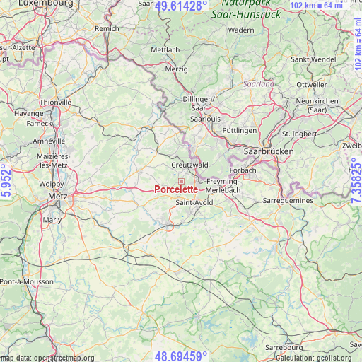
Porcelette GPS coordinates[2]
49° 9' 23.652" North, 6° 39' 18.468" East
| Map corner | latitude | longitude |
|---|---|---|
| Upper-left | 49.61428°, | 5.952° |
| Center: | 49.15657°, | 6.65513° |
| Lower-right: | 48.69459°, | 7.35825° |
| Map W x H: | 102.3×102.3 km | = 63.6×63.6mi |
| max Lat: | 51.07786° ⇑16.6% North |
| Porcelette: | 49.15657° |
| min Lat: | ⇓83.4% South 41.3874° |
| min Long | Porcelette | max Long |
| -5.08615° | 6.65513° | 9.52242° |
| W 92.7%⇐ | ⇒7.3% E |
Elevation
Elevation of Porcelette is 259 m = 850 ft, and this is 65.3 m = 214 ft above average elevation for this country.
| Max E: |
2333 m = 7654 ft | 23.6% |
| Porcelette | 259 m 850 ft | |
| Avg. | 193.7 m = 635 ft | |
Min E: |
-1 m = -3 ft | 76.4% |
See also: France elevation on elevation.city.
Geographical zone
Porcelette is located in North temperate zone (between Tropic of Cancer and the Arctic Circle). Distance of this North polar circle is 1935.5 km =1202.7 mi to North.| Distance of | km | miles | from Porcelette |
|---|---|---|---|
| North Pole | 4541.4 | 2821.9 | to North |
| Arctic Circle | 1935.5 | 1202.7 | to North |
| Tropic Cancer | 2859.8 | 1777 | to South |
| Equator | 5465.7 | 3396.2 | to South |


Nearby cities:
15 places around Porcelette: (largest is in red/bold)
• Bambiderstroff
7.5 km =4.7 mi,  217°
217°
• Boucheporn
3.8 km =2.4 mi,  242°
242°
• Carling
4.5 km =2.8 mi,  76°
76°
• Coume
7.6 km =4.7 mi,  307°
307°
• Creutzwald
6.2 km =3.9 mi,  29°
29°
• Diesen
2.9 km =1.8 mi, 34°
• Falck
8 km =5 mi,  348°
348°
• Guerting
4.2 km =2.6 mi,  326°
326°
• Ham-sous-Varsberg
2.7 km =1.7 mi, 347°
• Hargarten-aux-Mines
8.1 km =5 mi,  338°
338°
• Longeville-lès-Saint-Avold
4.5 km =2.8 mi,  191°
191°
• Saint-Avold
6.8 km =4.2 mi,  148°
148°
• Valmont
8.6 km =5.3 mi,  158°
158°
• Varsberg
2.6 km =1.6 mi, 313°
• Zimming
6.1 km =3.8 mi,  233°
233°
Sources, notices
• [Note1] Compared only with cities in France existing in our database
• [Src1] Map data: © OpenStreetMap contributors (CC-BY-SA)
• [Src2] Other city data from geonames.org with taken over terms of usage.
• [Src3] Geographical zone / Annual Mean Temperature by Robert A. Rohde @ Wikipedia
