Vouneuil-sous-Biard geodata
Vouneuil-sous-Biard (Nouvelle-Aquitaine) is a populated place; located in France in Europe/Paris (GMT+2) time zone. With population of 4,391 people, there are 2249 cities with bigger population in this country. Compared to other cities in France, 59.5% of cities are located further ↑North; 75.6% of cities are located further →East and 53.1% of cities have higher elevation than Vouneuil-sous-Biard. Note1
Administrative division(s):
- Level 1: Nouvelle-Aquitaine
- Level 2: Vienne
- Level 3: Arrondissement de Poitiers
- Level 4: Vouneuil-sous-Biard


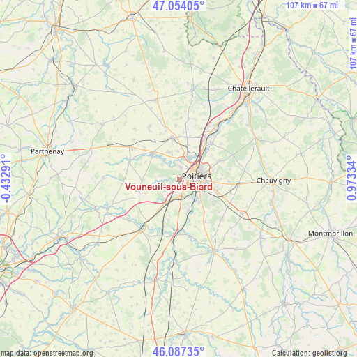
Vouneuil-sous-Biard GPS coordinates[2]
46° 34' 22.26" North, 0° 16' 12.792" East
| Map corner | latitude | longitude |
|---|---|---|
| Upper-left | 47.05405°, | -0.43291° |
| Center: | 46.57285°, | 0.27022° |
| Lower-right: | 46.08735°, | 0.97334° |
| Map W x H: | 107.5×107.5 km | = 66.8×66.8mi |
| max Lat: | 51.07786° ⇑59.5% North |
| Vouneuil-sous-Biard: | 46.57285° |
| min Lat: | ⇓40.5% South 41.3874° |
| min Long | Vouneuil-sous-B | max Long |
| -5.08615° | 0.27022° | 9.52242° |
| W 24.4%⇐ | ⇒75.6% E |
Elevation
Elevation of Vouneuil-sous-Biard is 122 m = 400 ft, and this is 71.7 m = 235 ft below average elevation for this country.
| Max E: |
2333 m = 7654 ft | 53.1% |
| Avg. | 193.7 m = 635 ft | |
| Vouneuil-sous-Biard | 122 m = 400 ft | |
Min E: |
-1 m = -3 ft | 46.9% |
See also: France elevation on elevation.city.
Geographical zone
Vouneuil-sous-Biard is located in North temperate zone (between Tropic of Cancer and the Arctic Circle). Distance of this North polar circle is 2222.8 km =1381.2 mi to North.| Distance of | km | miles | from Vouneuil-sous-Biard |
|---|---|---|---|
| North Pole | 4828.6 | 3000.4 | to North |
| Arctic Circle | 2222.8 | 1381.2 | to North |
| Tropic Cancer | 2572.5 | 1598.5 | to South |
| Equator | 5178.4 | 3217.7 | to South |


Nearby cities:
15 places around Vouneuil-sous-Biard: (largest is in red/bold)
• Avanton
10.3 km =6.4 mi,  14°
14°
• Biard
2.7 km =1.7 mi,  79°
79°
• Béruges
4.8 km =3 mi,  262°
262°
• Cissé
8.7 km =5.4 mi,  338°
338°
• Croutelle
3.9 km =2.4 mi,  156°
156°
• Fontaine-le-Comte
4.7 km =2.9 mi,  187°
187°
• Iteuil
9.9 km =6.2 mi, 161°
• Ligugé
7.3 km =4.5 mi,  143°
143°
• Migné
7 km =4.3 mi,  29°
29°
• Montreuil-Bonnin
10.1 km =6.3 mi, 256°
• Poitiers
5.7 km =3.5 mi, 79°
• Roman catholic diocese of Poitiers
6.1 km =3.8 mi, 82°
• Saint-Benoît
6 km =3.7 mi,  114°
114°
• Smarves
9.2 km =5.7 mi, 138°
• Vouillé
10.9 km =6.8 mi,  314°
314°
Sources, notices
• [Note1] Compared only with cities in France existing in our database
• [Src1] Map data: © OpenStreetMap contributors (CC-BY-SA)
• [Src2] Other city data from geonames.org with taken over terms of usage.
• [Src3] Geographical zone / Annual Mean Temperature by Robert A. Rohde @ Wikipedia
