Fontaine-le-Comte geodata
Fontaine-le-Comte (Nouvelle-Aquitaine) is a populated place; located in France in Europe/Paris (GMT+2) time zone. With population of 3,316 people, there are 2943 cities with bigger population in this country. Compared to other cities in France, 59.9% of cities are located further ↑North; 75.7% of cities are located further →East and 53.1% of cities have lower elevation than Fontaine-le-Comte. Note1
Administrative division(s):
- Level 1: Nouvelle-Aquitaine
- Level 2: Vienne
- Level 3: Arrondissement de Poitiers
- Level 4: Fontaine-le-Comte


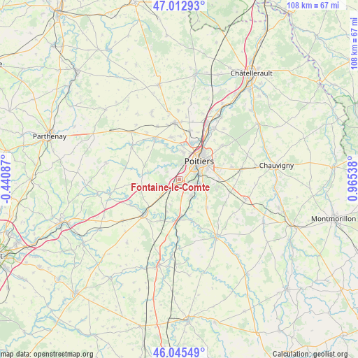
Fontaine-le-Comte GPS coordinates[2]
46° 31' 52.896" North, 0° 15' 44.136" East
| Map corner | latitude | longitude |
|---|---|---|
| Upper-left | 47.01293°, | -0.44087° |
| Center: | 46.53136°, | 0.26226° |
| Lower-right: | 46.04549°, | 0.96538° |
| Map W x H: | 107.6×107.6 km | = 66.9×66.9mi |
| max Lat: | 51.07786° ⇑59.9% North |
| Fontaine-le-Comte: | 46.53136° |
| min Lat: | ⇓40.1% South 41.3874° |
| min Long | Fontaine-le-Com | max Long |
| -5.08615° | 0.26226° | 9.52242° |
| W 24.3%⇐ | ⇒75.7% E |
Elevation
Elevation of Fontaine-le-Comte is 143 m = 469 ft, and this is 50.7 m = 166 ft below average elevation for this country.
| Max E: |
2333 m = 7654 ft | 46.9% |
| Avg. | 193.7 m = 635 ft | |
| Fontaine-le-Comte | 143 m = 469 ft | |
Min E: |
-1 m = -3 ft | 53.1% |
See also: France elevation on elevation.city.
Geographical zone
Fontaine-le-Comte is located in North temperate zone (between Tropic of Cancer and the Arctic Circle). Distance of this North polar circle is 2227.4 km =1384 mi to North.| Distance of | km | miles | from Fontaine-le-Comte |
|---|---|---|---|
| North Pole | 4833.3 | 3003.3 | to North |
| Arctic Circle | 2227.4 | 1384 | to North |
| Tropic Cancer | 2567.9 | 1595.6 | to South |
| Equator | 5173.8 | 3214.8 | to South |


Nearby cities:
15 places around Fontaine-le-Comte: (largest is in red/bold)
• Biard
6.1 km =3.8 mi,  32°
32°
• Béruges
5.8 km =3.6 mi,  313°
313°
• Coulombiers
7.6 km =4.7 mi,  228°
228°
• Croutelle
2.4 km =1.5 mi,  65°
65°
• Iteuil
6.1 km =3.8 mi,  141°
141°
• La Chapelle-Montreuil
11.1 km =6.9 mi,  271°
271°
• Ligugé
5.1 km =3.2 mi,  104°
104°
• Marçay
8.1 km =5 mi,  199°
199°
• Montreuil-Bonnin
9.5 km =5.9 mi,  284°
284°
• Poitiers
8.4 km =5.2 mi,  47°
47°
• Roches-Prémarie-Andillé
9.7 km =6 mi,  122°
122°
• Roman catholic diocese of Poitiers
8.6 km =5.3 mi, 50°
• Saint-Benoît
6.4 km =4 mi, 70°
• Smarves
7.1 km =4.4 mi,  108°
108°
• Vouneuil-sous-Biard
4.7 km =2.9 mi,  7°
7°
Sources, notices
• [Note1] Compared only with cities in France existing in our database
• [Src1] Map data: © OpenStreetMap contributors (CC-BY-SA)
• [Src2] Other city data from geonames.org with taken over terms of usage.
• [Src3] Geographical zone / Annual Mean Temperature by Robert A. Rohde @ Wikipedia
