Vif geodata
Vif (Auvergne-Rhône-Alpes) is a populated place; located in France in Europe/Paris (GMT+2) time zone. With population of 6,942 people, there are 1425 cities with bigger population in this country. Compared to other cities in France, 79% of cities are located further ↑North; 84.2% of cities are located further ←West and 82.4% of cities have lower elevation than Vif. Note1
Administrative division(s):
- Level 1: Auvergne-Rhône-Alpes
- Level 2: Département de l'Isère
- Level 3: Arrondissement de Grenoble
- Level 4: Vif


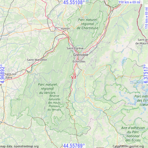
Vif GPS coordinates[2]
45° 3' 23.544" North, 5° 40' 19.344" East
| Map corner | latitude | longitude |
|---|---|---|
| Upper-left | 45.55108°, | 4.96892° |
| Center: | 45.05654°, | 5.67204° |
| Lower-right: | 44.55769°, | 6.37517° |
| Map W x H: | 110.5×110.5 km | = 68.7×68.7mi |
| max Lat: | 51.07786° ⇑79% North |
| Vif: | 45.05654° |
| min Lat: | ⇓21% South 41.3874° |
| min Long | Vif | max Long |
| -5.08615° | 5.67204° | 9.52242° |
| W 84.2%⇐ | ⇒15.8% E |
Elevation
Elevation of Vif is 314 m = 1030 ft, and this is 120.3 m = 395 ft above average elevation for this country.
| Max E: |
2333 m = 7654 ft | 17.6% |
| Vif | 314 m 1030 ft | |
| Avg. | 193.7 m = 635 ft | |
Min E: |
-1 m = -3 ft | 82.4% |
See also: France elevation on elevation.city.
Geographical zone
Vif is located in North temperate zone (between Tropic of Cancer and the Arctic Circle). Distance of this North polar circle is 2391.4 km =1485.9 mi to North.| Distance of | km | miles | from Vif |
|---|---|---|---|
| North Pole | 4997.2 | 3105.1 | to North |
| Arctic Circle | 2391.4 | 1485.9 | to North |
| Tropic Cancer | 2403.9 | 1493.7 | to South |
| Equator | 5009.8 | 3112.9 | to South |


Nearby cities:
15 places around Vif: (largest is in red/bold)
• Allières-et-Risset
4.8 km =3 mi,  6°
6°
• Champ-sur-Drac
4.9 km =3 mi,  72°
72°
• Champagnier
7.5 km =4.7 mi,  35°
35°
• Claix
7 km =4.3 mi,  0°
0°
• Jarrie
9.6 km =6 mi,  45°
45°
• Le Gua
6.2 km =3.9 mi,  224°
224°
• Le Pont-de-Claix
7.7 km =4.8 mi,  15°
15°
• Notre-Dame-de-Mésage
6.8 km =4.2 mi,  84°
84°
• Saint-Barthélemy
7.1 km =4.4 mi,  207°
207°
• Saint-Georges-de-Commiers
3 km =1.9 mi,  114°
114°
• Saint-Paul-de-Varces
2.9 km =1.8 mi,  306°
306°
• Saint-Pierre-de-Mésage
9.4 km =5.8 mi,  96°
96°
• Villard-de-Lans
9.2 km =5.7 mi,  280°
280°
• Vizille
8.1 km =5 mi, 72°
• Échirolles
10.5 km =6.5 mi, 18°
Sources, notices
• [Note1] Compared only with cities in France existing in our database
• [Src1] Map data: © OpenStreetMap contributors (CC-BY-SA)
• [Src2] Other city data from geonames.org with taken over terms of usage.
• [Src3] Geographical zone / Annual Mean Temperature by Robert A. Rohde @ Wikipedia
